Friday, July 14, 2006

Making Waves

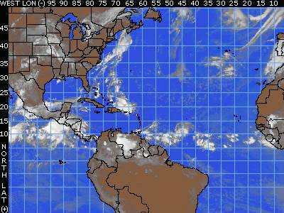
The next tropical wave to be concerned with is roughly along 70 west, south of 20 north. It is moving west-northwestward at about 15 knots. There are no signs of organization with this wave at the moment and shear caused by westerly winds aloft will prevent any development along this wave in the near future. The wave is causing showers and thunderstorms in Puerto Rico and the Virgin Islands Thursday night that will reach Hispaniola Friday. This wave will eventually reach South Florida by Sunday.

A weak wave is around 54 west, south of 12 north. There are a few scattered showers from this system, but no development is expected.

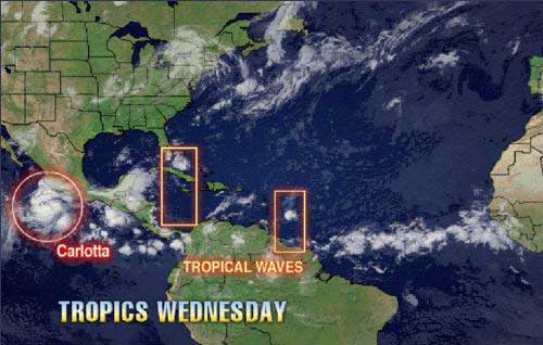
Another tropical wave is out over the open Atlantic to the southwest of the Cape Verde Islands along 30 west, south of 15 north. There appears to be an area of low pressure along this wave centered near 27 west and 13 north, as evidenced by a swirl of clouds on satellite pictures of the region. While in minimal shear at this point it will continue to head toward a region where more shear is expected. Development is not expected.

Another wave is moving through western Africa and should form another Atlantic tropical wave later Friday.

Wednesday, July 12, 2006

A Tropical Wave East of the Lesser Antilles Might Have Favorable Conditions for Development in a Few Days


We are tracking tropical waves along 74 west and along 53 west. The wave along 74 west extends to about 21 north and is moving to the west at 10-15 knots or about 6 degrees longitude per day. This wave is causing an increase in clouds, showers and thunderstorms over the Bahamas and eastern Cuba, as well as parts of Columbia. That wave will help bring a moisture surge into South and central Florida Wednesday and Thursday. A large area of dry air follows this wave over the Leeward Islands.

The wave along 53 west has a curved cloud structure that extends up to about 15 north with a 1012 mb low associated with it. This wave is moving westward at about 6 degrees longitude per day. Microwave satellite images show clusters of thunderstorms and a slight rotary motion in the thunderstorm pattern. This is often the beginning sign of a possible low-level or upper-level feature forming. For the first time this tropical season, the shear has relaxed over the Lesser Antilles and the eastern Caribbean. Current shear in the path of this wave is generally less than 10 knots and that is not enough to kill the wave. Another problem with this season thus far has been higher-than-normal surface pressures over the Caribbean. Current surface data indicates that surface pressures are lower today compared to last week and are near normal for the most part. If surface pressure continues to lower and the shear continues to relax over the eastern Caribbean and near the Lesser Antilles, this wave could try to organize in a few days. This wave will move into the Lesser Antilles Wednesday night and Thursday.

Monday, July 10, 2006

Model forecast tracks / A normal July

Model forecast tracks for the tropical wave approaching the Lesser Antilles Islands.

The curve of historical normal hurricane activity of the Atlantic Ocean.

Tropical Development Unlikely

A tropical wave is causing a few showers and thunderstorms from Puerto Rico to just north of the Dominican Republic and northward still into the Bahamas. While there is considerable convection with this wave, there will be little organized storminess at this point. These thunderstorms have been ongoing for the past 24 hours, but tropical development is unlikely over the coming days due to wind shear and stronger-than-average surface pressures in their path. This disturbance should reach Florida by Wednesday, causing an increase in thunderstorm activity.

Another tropical wave is located near 44/45 west, south of 15 north and is moving to the west at 15 knots. Thunderstorms have become better organized with the wave, and a small surface low with a minimum pressure of 1012 mb has developed. This wave shows small promise for future development, but it will also be entering an area of some wind shear near the Leeward Islands.