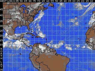
 A tropical wave is causing a few showers and thunderstorms from Puerto Rico to just north of the Dominican Republic and northward still into the Bahamas. While there is considerable convection with this wave, there will be little organized storminess at this point. These thunderstorms have been ongoing for the past 24 hours, but tropical development is unlikely over the coming days due to wind shear and stronger-than-average surface pressures in their path. This disturbance should reach Florida by Wednesday, causing an increase in thunderstorm activity.
 Another tropical wave is located near 44/45 west, south of 15 north and is moving to the west at 15 knots. Thunderstorms have become better organized with the wave, and a small surface low with a minimum pressure of 1012 mb has developed. This wave shows small promise for future development, but it will also be entering an area of some wind shear near the Leeward Islands.
