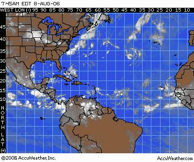
 A tropical low pressure area about 1,075 miles east of the Windward Islands is moving to the west at about 6 degrees longitude per day. Satellite images showed a rotating mass of clouds with some thunderstorms growing within this mass. The center of this mass of clouds was roughly 12.0 north and 44.0 west. If thunderstorms continue to develop around this swirl of clouds, we could have a depression within the next 24-36 hours. A buoy located just northwest of the low continued to show falling pressure, suggesting this feature is trying to organize. Upper-level winds over this feature are not very strong. So, the shear over it is relatively light. Given the usual very warm water, this system is in a good position for development. In the coming days, as the low continues to track westward it would be in an area where the wind shear is less and thus the upper-level winds are more favorable for development. Current computer projections place this low pressure area in the Lesser Antilles Thursday night, then into the eastern Caribbean on Friday, but these models are showing little or no respect for this feature. All global models eventually show the system falling apart as it moves into the Lesser Antilles. An upper-level trough extending over the eastern Caribbean late in the week might create the shear that would prevent this system from developing further. So, speculating on this system beyond Friday is nearly impossible at this time.
 Elsewhere in the tropical Atlantic we are tracking tropical waves along 28 west, 17 north and 73 west, 23 north and all south of 25 north. Both of these waves are moving west at an average speed of 6-7 degrees longitude per day. The wave near 73 west is interacting with an upper-level low near the eastern Bahamas. However, there is presently too much wind shear in this area and thus no further development is expected with this wave. It will bring an increase in moisture over South Florida on Wednesday, leading to more showers and thunderstorms.
