Wednesday, June 14, 2006

Alberto downgraded as it steams across Southeast

After splashing ashore in Florida without its once-feared punch, the remnants of the first named storm of the season churned through the Southeast early Wednesday, bringing much-needed rain and offering a tune-up for officials readying for the long hurricane season.

By early Wednesday morning, Alberto had weakened from a tropical storm to a tropical depression over South Carolina and all tropical storm warnings were discontinued, forecasters at the National Hurricane Center said. The storm was expected to lose all tropical characteristics later in the day, though it was possible the storm could strengthen again.

After last year's 28 named storms and record 15 hurricanes, Tropical Storm Alberto caused a brief scare and prompted a call for more than 20,000 people to evacuate Florida's Gulf Coast. But no serious injuries or deaths were reported.

Tuesday, June 13, 2006

Alberto leaves thousands powerless on Gulf Coast

Tropical Storm Alberto pelted Florida's Gulf Coast with rain before it made landfall Tuesday, but early reports indicated its winds, storm surge and other effects were not as serious as initially feared.

The storm's center came ashore around 12:30 p.m. near Adams Beach, about 50 miles southeast of Tallahassee, the National Hurricane Center said. Alberto's top sustained winds were 40 mph, down from 65 mph earlier in the day. The minimum wind speed for a hurricane is 74 mph.

About 21,000 homes and businesses were without power statewide and some streets flooded in coastal towns. Water levels approached several houses and businesses near Crystal River to the south. Residents gathered in calf-deep water on streets and parking lots and dropped sandbags in preparation for the afternoon high tide.

Little damage reported from Alberto in Fla

CEDAR KEY, Fla. - The first tropical storm of the 2006 Atlantic hurricane season pelted Florida's gulf coast with rain Tuesday, but forecasters said Alberto wouldn't reach hurricane strength as earlier feared.

The National Hurricane Center downgraded its hurricane warning on parts of Florida's Gulf Coast to a tropical storm warning midmorning.

Alberto's top sustained winds had dropped to 50 mph, well below the 74 mph threshold for a hurricane.

Alberto weakens as it nears landfall

Thousands ordered to flee ahead of tropical storm

A slightly weakened Tropical Storm Alberto approached the northern Gulf Coast of Florida early Tuesday, with maximum sustained winds at 65 mph, the National Hurricane Center reported.

A hurricane warning was in place from the Tampa Bay area to near Tallahassee.

Forecasters urged people to quickly make "preparations to protect life and property" as the eye of Alberto neared shore.

The NHC currently predicts the storm could make landfall about midday.

Florida Gov. Jeb Bush issued a mandatory evacuation order for low-lying counties Dixie, Levy, Taylor, Citrus, Franklin and Wakulla, which are in the storm's path.

At 5 a.m. EDT, the center of Alberto was about 60 miles southeast of Apalachicola and about 65 miles west of Cedar Key, moving northeast at about 9 mph. Forecasters said it is likely to continue on that path through midday.

Forecasters reported coastal storm surging up to 8 to 10 feet above normal tide levels over a large portion of the warning area -- conditions that could trigger floods and mudslides -- are expected.

Rainfall could reach 10 inches Tuesday across portions of central and northern Florida and southeastern Georgia.

The hurricane warning stretches from the Ochlockonee River south to Longboat Key.

Bush advised Florida residents in the path of the storm to ensure they have enough supplies like food, medicine, water and a full tank of gas to last at least 72 hours.

Florida state officials have reported no gas shortages and said the ports are open for now, although the port of Tampa is evaluating whether to stay open.

Monday, June 12, 2006

Hurricane warning issued for Alberto

Forecasters issued a hurricane warning for parts of Florida's Gulf Coast on Monday as the first named storm of the 2006 Atlantic hurricane season quickly gained strength in the Gulf of Mexico.

The warning from Longboat Key near Sarasota to the Ochlockonee River south of Tallahassee means Tropical Storm Alberto was expected to produce hurricane conditions within the next 24 hours.

A tropical storm warning remains in effect for Longboat Key to Englewood.

At 11 a.m., Alberto's winds had increased to 70 mph, up from 50 mph just three hours earlier. The storm was centered about 190 miles south-southwest of Apalachicola and was moving north-northeast at about 7 mph, National Hurricane Center forecasters said.

Storm warning issued for Fla.'s Gulf Coast

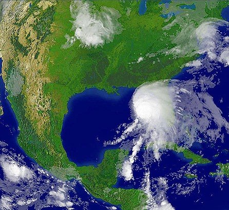
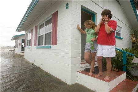
TAMPA, Fla. - The first named storm of the 2006 Atlantic hurricane season slightly strengthened early Monday in the Gulf of Mexico, prompting forecasters to issue tropical storm warnings for Florida's west coast.

Tropical Storm Alberto had maximum sustained wind near 50 mph but was not likely to grow into a hurricane, the National Hurricane Center said. There were no major reports of damage.

At 5 a.m. EDT, Alberto was centered about 275 miles south-southwest of Apalachicola. It was moving north-northeast at about 8 mph and could make landfall Tuesday night, forecasters said.

"Right before landfall they expect a little stronger: 55 gusts to 65. It won't be quite hurricane strength," said Ron Goodman, a meteorologist at the National Hurricane Center. "Things can change, but right now it's not expected to be a hurricane."

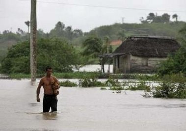
Forecasters said that up to 30 inches of rain could fall over some parts of Cuba, creating a threat of flash floods and mudslides, and that 5 to 10 inches could fall over the Florida peninsula through Tuesday. Over the Florida Keys, between 3 to 5 inches of rainfall are possible.

A tropical storm warning was issued for most of Florida's west coast, from Englewood to Indian Pass, meaning tropical storm conditions were expected there within the next 24 hours. A tropical storm watch remains in effect from south of Englewood to Bonita Beach.

The tropical depression that produced Alberto formed Saturday, nine days after the official start of the hurricane season, in the northwest Caribbean, which can produce typically weak storms that follow a similar track this time of year, forecasters said.

Last year's hurricane season was the most destructive on record. Hurricane Katrina devastated Louisiana and Mississippi and was blamed for more than 1,570 deaths among Louisiana residents alone.

This year, however, meteorologists have said the Atlantic is not as warm as it was at this time in 2005, meaning potential storms would have less of the energy needed to develop into hurricanes.

Last year's first named storm was Tropical Storm Arlene, which formed June 9 and made landfall just west of Pensacola in the Florida Panhandle.