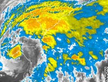
 Thousands ordered to flee ahead of tropical storm
 A slightly weakened Tropical Storm Alberto approached the northern Gulf Coast of Florida early Tuesday, with maximum sustained winds at 65 mph, the National Hurricane Center reported.
A hurricane warning was in place from the Tampa Bay area to near Tallahassee.
Forecasters urged people to quickly make "preparations to protect life and property" as the eye of Alberto neared shore.
The NHC currently predicts the storm could make landfall about midday.
Florida Gov. Jeb Bush issued a mandatory evacuation order for low-lying counties Dixie, Levy, Taylor, Citrus, Franklin and Wakulla, which are in the storm's path.
At 5 a.m. EDT, the center of Alberto was about 60 miles southeast of Apalachicola and about 65 miles west of Cedar Key, moving northeast at about 9 mph. Forecasters said it is likely to continue on that path through midday.
Forecasters reported coastal storm surging up to 8 to 10 feet above normal tide levels over a large portion of the warning area -- conditions that could trigger floods and mudslides -- are expected.
Rainfall could reach 10 inches Tuesday across portions of central and northern Florida and southeastern Georgia.
The hurricane warning stretches from the Ochlockonee River south to Longboat Key.
Bush advised Florida residents in the path of the storm to ensure they have enough supplies like food, medicine, water and a full tank of gas to last at least 72 hours.
Florida state officials have reported no gas shortages and said the ports are open for now, although the port of Tampa is evaluating whether to stay open.
