Friday, July 07, 2006

Disturbed weather in the northwest Caribbean is being watched

An upper level system, extending from near Florida toward the southwest across the southeast Gulf of Mexico and into the northwest Caribbean Sea, continues to generate showers and thunderstorms from the U.S. southeast coast southwest into the northwest Caribbean. A surface low will devleop along a weak front moving into the southeast U.S. and become better developed near the Carolina coast later today and Saturday then lift northeast. We see no tropical development with this low. However, a tropical wave along 85 west near 22 north angles back south southwest into the northwest Caribbean. This tropical wave is interacting with the upper level system and this is leading to enhanced thunderstorms from western Cuba southward into eastern Nicarague and Honduras. Surface pressures in this area remain too high for possible development within the next couple of days and the wave is moving westward at about 7 to 8 degrees longitude per day. So, this feature will be over the Yucatan tomorrow, slow down and move into the southwest Gulf Saturday night and Sunday. There is a slight chance this system could organize in the far southwest Gulf of Mexico on Sunday.

Elsewhere in the Atlantic Basin a tropical waves along 60 west and along 45 west are moving west at about 15kts. Both waves are surrounded by African dust at this time. This dust will continue to suppress thunderstorm development in and around these tropical waves. A new wave is emerging off the African coast just east of 20 west. t too is surrounded by dust and the thunderstorms around it will probably diminish witin the next 24 hours as it heads west.

A large area of African dust covers the eastern Caribbean eastward across the tropical Atlantic. As we have been stating all week this large area of dust is creating a strong inversion which will continue to suppress convective development. Given no large scale shower and thunderstorm development it will be very difficult for any tropical development over the eastern Caribbean into the western tropical Atlantic for the next few days.
Thursday, July 06, 2006

Tropical Atlantic remains quiet

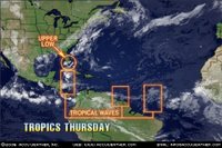
The Atlantic Basin continues to look fairly quiet. We continue to monitor an area of clouds, showers and thunderstorms over the northern Bahamas into southeast Florida. This area of disturbed weather is associated with a weak upper level low that is centered near Miami Florida. This upper level feature will move west northwest over the next 24 hours then become oval shaped and oriented northeast to southwest on Friday as an upper level system moves into the Southeast U.S.. A weak cool front supported by this upper level system dropping into the Southeast U.S. will reach northern Florida tomorrow night. This very complex weather pattern will cause a surface low to form over southeast Georgia tomorrow night. That low pressure are will move northeast close to the South and North Carolina coast during Friday and Friday night. This will not be a tropical feature at this point. However, it could become a non tropical storm system as it moves northeast Friday night and Saturday.

Elsewhere in the tropics we are monitoring tropical waves along 76 west south of 22 north, along 52 west south of 11 north and along 35 west south of 13 north. These waves are moving to the west at about 15-20 knots or about 7 degrees longitude per day. The wave along 76 west is enhancing thunderstorm development over eastern Cuba and over the southern Caribbean. But there is little shower or thunderstorm development over the middle Caribbean. We expect this wave to be along 82 west late tomorrow and near 90 west by Friday evening. This will help produce an increase in thunderstorms over the Yucatan peninsula during Friday. This wave might be something to watch over the weekend as it moves into the Bay of Campeche or the southwest Gulf of Mexico.

Wednesday, July 05, 2006

Florida coral battered by hurricanes and disease

DRY TORTUGAS NATIONAL PARK, Florida (Reuters) - In the azure waters of Florida's remote Dry Tortugas National Park, corals have been toppled by hurricanes and blighted by disease and a phenomenon known as bleaching.

Eight hurricanes in two years and a plague of disease that swept the Caribbean recently have damaged the colorful, thick carpets of open-water coral reefs in the 100-square-mile (260-sq-km) park off Florida's southwest coast.

With another hurricane season under way and diseases such as white plague getting an early start this year, scientists surveying the reef expressed heightened concern for the fragile corals, which are important nurseries and habitats for marine life and harbingers of the health of the seas.

"There are some areas out here that are like a parking lot, absolutely denuded," said Dr. Jerry Ault, associate professor of marine biology and fisheries at the University of Miami's Rosenstiel School of Marine & Atmospheric Science.

Ault supervised a team of nearly 40 divers aboard the 100-foot (30-meter) research vessel Spree recently as they conducted a three-week, $300,000 biennial census, surveying coral, fish and lobster.

The Dry Tortugas are a cluster of seven tiny islands and acres (hectares) of coral seabed located 70 miles southwest of Key West, a popular tourist island at the southern tip of the Florida peninsula.

"Since 2004, we have had eight storms that have tracked within 100 miles of the Tortugas," said Ault. "In 2005, this was ground zero for major storms.

"Are we afraid of another hurricane season? Three (bad) hurricane seasons can't be a good thing."

"Coral reefs are in a state of decline around the world," said Billy Causey, acting regional manager for national marine sanctuaries in the southeast United States. "At least we have protections in place. There's probably not a piece of coral reef real estate that is any more protected."

The Tropical Atlantic remains relatively quiet

The upper level low just east of Florida and a tropical wave along 70 west are our main concerns for any possible tropical development. At this point we don either system within the next couple of days due to strong shear and higher than normal surface pressure. The wave along 70 west is handled differently by various computer models. There is some attempt by one model to show some organization of this wave within the next 3 days. However, we don't see that on other model output. A large area of African dust that we have been stating over the past few days continues to advance westward and is now entering the eastern Caribbean. This African dust represents drier than normal air at about 10,000 feet. This tends to put a lid on thunderstorm development. This drier air is feeding into the back of the wave along 70 west and this will also hinder development.

We are tracking other tropical waves. They are along: 30 west south of 15 north, along 45 west south of 15 north and along 85 west south of 13 north. These tropical waves are moving west at 15-20 knots or about 7 degrees longitude per day. We see no support for any development by any of these waves.

Looking back a year ago for July 4-5 we had two tropical depressions one became Cindy and the other was Dennis. We have had only one tropical cyclone so far this season and this is much closer to a near normal season. We believe the reason we have not seen any quick development like last year is due to several factors. As stated above we are seeing surface pressures a bit higher than normal over the Caribbean compared to lower than normal last year. We also continue to see strong shearing over the eastern Gulf of Mexico down into the Caribbean due to frequent upper level troughs forming over the eastern U.S.. through the Caribbean. Current trends in longer range computer output suggests these conditions should persist through the next 5-7 days and perhaps longer.