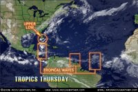
 The Atlantic Basin continues to look fairly quiet. We continue to monitor an area of clouds, showers and thunderstorms over the northern Bahamas into southeast Florida. This area of disturbed weather is associated with a weak upper level low that is centered near Miami Florida. This upper level feature will move west northwest over the next 24 hours then become oval shaped and oriented northeast to southwest on Friday as an upper level system moves into the Southeast U.S.. A weak cool front supported by this upper level system dropping into the Southeast U.S. will reach northern Florida tomorrow night. This very complex weather pattern will cause a surface low to form over southeast Georgia tomorrow night. That low pressure are will move northeast close to the South and North Carolina coast during Friday and Friday night. This will not be a tropical feature at this point. However, it could become a non tropical storm system as it moves northeast Friday night and Saturday.
 Elsewhere in the tropics we are monitoring tropical waves along 76 west south of 22 north, along 52 west south of 11 north and along 35 west south of 13 north. These waves are moving to the west at about 15-20 knots or about 7 degrees longitude per day. The wave along 76 west is enhancing thunderstorm development over eastern Cuba and over the southern Caribbean. But there is little shower or thunderstorm development over the middle Caribbean. We expect this wave to be along 82 west late tomorrow and near 90 west by Friday evening. This will help produce an increase in thunderstorms over the Yucatan peninsula during Friday. This wave might be something to watch over the weekend as it moves into the Bay of Campeche or the southwest Gulf of Mexico.
