A tropical storm warning remains in effect for the islands of Anguilla, St. Bartholomew, St. Martin and St. Maarten.
A tropical storm warning is in effect for Puerto Rico, the U.S. Virgin Islands and the British Virgin Islands.
The tropical storm warning for St. Kitts, Nevis, Antigua, and Barbuda has been discontinued.
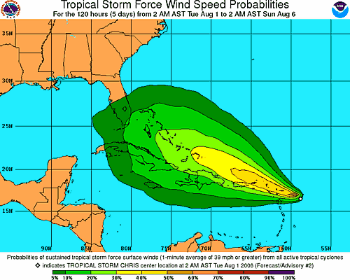
At 4:00 a.m. EDT, Tropical Storm Chris was still churning up the waters just to the northeast of the Leeward Islands. The storm was centered at 18.7 north, 62.5 west, 230 miles east of San Juan, Puerto Rico. The maximum winds were still 60 mph. The storm is moving west-northwest at around 9 mph and the minimum pressure was estimated to be 1002 millibars, or 29.59 inches of mercury. The tropical-storm-force winds extend outward up to 75 miles, mainly northeast from the storm's center. None of the observing sites in the Lesser Antilles are indicating any strong winds as of 5:00 a.m. EDT, though some are reporting weaker squalls associated with the storm. Being on the weaker side of the storm, most of the islands will probably only get tropical-storm-force winds in occasional gusts with the heaviest squalls. Rainfall amounts of 3-6 inches are possible over the Leeward Islands tonight and tomorrow and over the British Virgin Islands, the U.S. Virgin Islands and Puerto Rico tomorrow and tomorrow night. The mountains of Puerto Rico could help produce even more rainfall and perhaps dangerous mudslides if Chris comes close enough to that island tomorrow and tomorrow night.
Chris appears to be consolidating, becoming better organized, and gaining strength. The environment around the storm is favorable for further strengthening. The waters around the storm are warm and warm to substantial depth. The winds aloft are light, so there is little shear to be concerned with. The trend toward strengthening should continue in the near term, and Chris could easily be a hurricane by tonight or early Thursday morningThe track forecast and thus the long term intensity forecast is much more problematic. The consensus of the computer models is for Chris to take a track more westerly than northwesterly, and eventually rake the northern coasts of Puerto Rico and then Hispaniola. This would not be the best conditions for intensification, as a portion of the storms circulation would be interrupted by the high mountain terrain on those islands. However, the computer models have shown a bias forecasting storms too far left. Should the storm end up staying just far enough to the north of the islands, then it will remain more intense as it begins to affect Cuba and the Bahamas by the end of the week, and then possibly South Florida or the Keys late this weekend.
What is more certain at this point is that the Virgin Islands will experience squally conditions and gusty winds over the next 24 hours, and Puerto Rico will be brushed by strong winds by late Wednesday. The northern coast of Hispaniola will experience the strong winds by Friday. All of these areas will receive the heavy rains described above, and the rains could be even more extreme in Hispaniola should the storm take a more westward track. Therefore, storm preparations should be near completion in Puerto Rico and those residing in or those that have interests in Haiti or the Dominican Republic should rush storm preparations to completion at this point. Residents of Cuba and the southern Bahamas, as well as South Florida and the Keys need to monitor the storm's approach carefully. There is a good chance that Chris will be churning through the Gulf of Mexico next week.There are other features to track elsewhere in the tropics. There is a tropical wave in the Bay of Campeche along 92 west, south of 22 north. Although there is some thunderstorm activity along the wave, there is no sign of organization and development is unlikely before the wave is fully over Mexico. A wave along 70 west, south of 15 north is moving west at about 6 degrees longitude per day. This wave is mostly over land and is the southern part of the parent wave that was responsible for the formation of Tropical Storm Chris. There is another tropical wave along 36 west, south of 18 north, which is just to the west of the Cape Verde Islands. This wave is moving to the west at about 15 knots. There is no sign of organization with this wave at this point, but there is spotty thunderstorm activity. Finally, a new wave is over the African coastline at about 18 west, south of 21 north, zipping rapidly west at about 20 knots. There is widespread thunderstorm activity with this wave, but no sign of organization with it just yet.