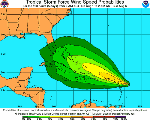
 The area of disturbed weather that we have been tracking the past few days east of the Lesser Antilles has intensified into the third named storm of the season. As of 8am, Tropical Storm Chris was located near 16.8 north and 59.8 west or 135 miles east of Antigua. The storm is moving to the west-northwest at 9 mph with maximum sustained winds of 35 mph. The central pressure is estimated at 1009 millibars or 29.80 inches.
A tropical storm warning has been issued for the islands of Antigua, Barbuda, Anguilla, St. Kitts, Nevis, Saba, St. Eustatius, St. Barthelemy, St. Martin, and St. Maarten, while a tropical storm watch is now in effect for Puerto Rico, the U.S. Virgin Islands, and the British Virgin Islands.
Tropical Storm Chris will bring squally conditions to the Leeward Islands Tuesday and Wednesday. But, since it will be moving through the Leeward Islands, friction caused by the islands might prevent the depression from intensifying. Computer models continue to show a west northwest course which will keep the system over or near the Greater Antilles. This could further prevent intensification, and a large upper-level low north of the Bahamas may shear the storm later this week. If the system can avoid most of the islands, we project the system will be somewhere between the central Bahamas and southeast Cuba by Friday. This system could directly affect Florida early next week.
Elsewhere in the tropics we are tracking a wave along 29 west south of 18 north. This wave is moving west at about 6 degrees longitude per day. Dry air surrounds this well devleoped wave. As stated earlier some computer model output implies this system might develop in a few days.
A tropical wave along 87 west is moving west at about 7-8 degrees longitude per day. This wave has no organization, but the shear over it is rather low. Since there are no signs of a lower-level feature showing up yet, we do not expect this system to develop anytime soon.
