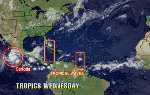
We are tracking tropical waves along 74 west and along 53 west. The wave along 74 west extends to about 21 north and is moving to the west at 10-15 knots or about 6 degrees longitude per day. This wave is causing an increase in clouds, showers and thunderstorms over the Bahamas and eastern Cuba, as well as parts of Columbia. That wave will help bring a moisture surge into South and central Florida Wednesday and Thursday. A large area of dry air follows this wave over the Leeward Islands.
The wave along 53 west has a curved cloud structure that extends up to about 15 north with a 1012 mb low associated with it. This wave is moving westward at about 6 degrees longitude per day. Microwave satellite images show clusters of thunderstorms and a slight rotary motion in the thunderstorm pattern. This is often the beginning sign of a possible low-level or upper-level feature forming. For the first time this tropical season, the shear has relaxed over the Lesser Antilles and the eastern Caribbean. Current shear in the path of this wave is generally less than 10 knots and that is not enough to kill the wave. Another problem with this season thus far has been higher-than-normal surface pressures over the Caribbean. Current surface data indicates that surface pressures are lower today compared to last week and are near normal for the most part. If surface pressure continues to lower and the shear continues to relax over the eastern Caribbean and near the Lesser Antilles, this wave could try to organize in a few days. This wave will move into the Lesser Antilles Wednesday night and Thursday.
