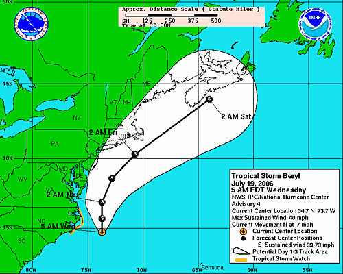
 Tropical Storm Beryl is located 110 miles east-southeast of Cape Hatteras, North Carolina. Beryl continues on a northerly track at 7 mph and maintain tropical storm strength over the next 24 to 48 hours. The storm will track northward, grazing the Outer Banks of North Carolina today. Based on this track, eastern North Carolina and perhaps southeastern Virginia and the Delmarva Peninsula would see some rain squalls with gusty winds tonight, and early Thursday before the storm accelerates northeastward with similar conditions around Cape Cod on Friday.
 A tropical storm watch remains in effect for the North Carolina coast from north of Cape Lookout to south of Currituck Beach Light.
Residents of the Outer Banks of North Carolina should be completed with storm preparations at this point, as this area will at least be brushed by Beryl. Those along the coast all the way to Cape Cod should keep a close watch on Beryl's progress, as any deviation west of the forecast track would result in areas around the coast to be directly affected. Outside of the main danger area, Beryl will cause rip currents, rough surf and some beach erosion, as well as possible coastal flooding along the Carolina and mid-Atlantic coasts.
Elsewhere in the Atlantic, there are a few tropical waves to follow. One tropical wave is moving across the Yucatan Peninsula and will eventually move over the Bay of Campeche Wednesday. The close proximity to land should prevent further organization or strengthening
Another tropical wave is along 68 west, south of 25 north. It is causing thunderstorms over the eastern Caribbean.
A third tropical wave in the open Atlantic, near 35 west, south of 16 north. There could be development along this wave over time as well, since the waters are progressively warmer in the path of the wave and there is no significant shear in the region.
