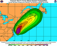
 A tropical storm warning has been issued for southeastern Massachusetts from Plymouth, southward and westward to Woods Hole. This includes Cape Cod, Nantucket Island and Martha's Vineyard. Additional watches and warnings may be necessary for parts of Long Island and the New England coastline.
Tropical Storm Beryl is about 295 miles south of Nantucket, Massachusetts, packing winds of 60 mph with gusts to 70 mph. As of 5:00 a.m. EDT Thursday, the center of Beryl was located near 37.8 north and 73.2 west. The storm is moving generally to the north at 9 mph. The surface pressure remains at 1002 millibars, or 29.59 inches. Beryl will continue on a northerly track and will increase in forward speed over the next 24 hours. The shear should increase Thursday morning as an upper-level trough approaches from the west, and will help to prevent any significant intensification Thursday. Also, Beryl will be moving over some cooler waters as it continues to head to the north. It should remain a very strong tropical storm through Thursday afternoon as it moves faster and on more of a northeasterly course. The increased shear will then cause the storm to weaken late Thursday and Thursday night. Our forecast will bring the center of Beryl over or near Nantucket early Friday morning. The system should track to the northeast of southeastern New England by later Friday morning and will start to transition to a non-tropical system as it approaches southern Nova Scotia Friday afternoon. Strong winds should continue to stay offshore until the storm moves close to eastern Long Island and over extreme southeastern New England later Thursday night and early Friday morning. We are expecting 15-30 mph winds with gusts to 40 mph along far eastern Long Island and extreme coastal New England. Places like Block Island and Nantucket Island could have higher wind gusts.
The greatest threat with Beryl will be rough surf and rip currents. All the way from Cape Cod southward to Cape Lookout, there will be an increased threat of rip currents. Swimmers and surfers are urged to use extreme caution or even avoid entering the surf through Friday, as rip currents can drown even the best swimmers.
