Tuesday, August 29, 2006

Ernesto Leaves Cuba and Heads toward Florida

At 5:00 a.m., EDT, Tuesday, the center of Tropical Storm Ernesto was located near 22.6 north and 78.9 west. It is just off the Cuban shoreline and is about 235 miles south-southeast of Miami, Florida, with maximum sustained winds of 45 mph. Ernesto was moving to the northwest at near 14 mph. The surface pressure is 1005 millibars or 29.68 inches.

A tropical storm warning and hurricane watch is in effect for the southern Peninsula of Florida from New Smyrna Beach southward on the east coast, and from Bonita Beach southward along the west coast. A tropical storm watch is in effect from Bonita Beach northward to Englewood on the Florida west coast. A tropical storm warning and hurricane watch also remains in effect for Lake Okeechobee and all of the Florida Keys from Ocean Reef to the Dry Tortugas. A tropical storm warning and hurricane watch also remains in effect for Anddros Island in the northwestern Bahamas, the Biminis and Grand Bahama Island. A tropical storm warning remains in effect for the Cuban provinces of Guantanamo, Santiago de Cuba, Granma, Holguin, Las Tunas and Camaguey and the Ragged Islands and Great Exuma Island in the central Bahamas.

As of Tuesday morning, Ernesto was just off the Cuban coastline on the eastern side of the island. The storm has been interacting with the 4,000-foot mountains of eastern Cuba and a weak upper-level low just southeast of Miami, Florida. This has caused the lower-level circulation around the storm to become poorly organized, and the upper-level low has fed drier air into the system causing thunderstorms to be even more disorganized. An Air Force Hurricane Hunter aircraft reported estimated surface winds of near tropical storm strength just of the northeastern Cuban coast during the late afternoon and evening hours of Monday. So the system remains a very weak tropical storm. Although surface reports over northeastern Cuba show nothing near tropical storm strength. We expect the lower-level circulation to redevelop along or just off shore of the northern Cuban coast this morning and into this afternoon. As the lower-level part of this system gets back over water, it should start to organize and strengthen again. The broader circulation around the storm will continue to interact with Cuba through Tuesday morning and that will limit how strong the system can become initially. However, once the system becomes better organized in the lower levels, the upper levels should shift away from Cuba due to the light upper-level winds. Once the entire system is over water, which will be around midday or early afternoon Tuesday, there is a good chance it will continue to strengthen. However, due to the long lasting encounter with land there is only a small chance Ernesto can become a hurricane before reaching the south Florida coast later Tuesday night. Ernesto will track west-northwest then more northwest during Tuesday. That will put the storm's center just south of Marathon Florida in the central Keys Tuesday evening.

An oval-shaped, upper-level high pressure area is currently located over the Southeast U.S. and northern Florida. This ridge will weaken and move eastward as a strong upper-level system moves east from the Plains. That upper-level trough has turned out to be much stronger and is moving faster than thought a few days ago. That is why the forecasted movement of Ernesto has changed so much over the past three days. The upper-level high is expected to weaken slowly and move east slowly today. This will allow Ernesto to move into South Florida late Tuesday night between Miami and Key West and move northward through the peninsula during the day Wednesday. This will lead to rain and thunderstorms over South Florida tonight and over central and South Florida during Wednesday and early Wednesday night.

Ernesto is expected to make a second United States landfall, along the Carolina coastline Friday. Ernestos will bring heavy rainfall to the northern Carolinas into the Virginias and toward the Northeast later this week.

Monday, August 28, 2006


The latest forecast, issued at 8 a.m. EDT, predicted that Ernesto would hit South Florida as a Category 1 hurricane, with sustained winds of about 80 mph. But forecasters reminded residents that intensity is very difficult to predict and Ernesto could be stronger when it arrives.

One reliable computer model favored ''the possibility of Ernesto becoming a Category 2 or even a Category 3 hurricane before making landfall along the Florida coast,'' according to forecaster Stacy Stewart of the National Hurricane Center in West Miami-Dade County.

Hispaniola Puts a Beating on Ernesto - South Florida Be Prepared


A hurricane warning is in effect for the southwestern peninsula of Haiti from the Haiti-Dominican Republic border westward to the southwest tip of Haiti. A hurricane warning also remains in effect for the Cuban provinces of Guantanamo, Santiago de Cuba, Ranma, Olguin, Las Tunas and Camaguey. A tropical storm watch is now in effect for the Cayman Islands, while a tropical storm warning is in effect for Jamaica. A hurricane watch is also in effect for the Florida Keys from Ocean Reef to the Dry Tortugas. The tropical storm warning is now in effect for Ragged Island and Great Exuma in the central Bahamas. A hurricane watch is now in effect for Andros Island and the northwestern Bahamas.

Ernesto continues to take a hit from Hispaniola as downsloping flow off of the western mountains of Haiti continues to entrain dry air into the circulation, causing it to remain at tropical storm strength. An upper level trough of low pressure on a west-southwest track across the Bahamas is shearing convection to the northeast of Ernesto and we may see another jump to the north of the center of circulation which may have implications on south Florida later Tuesday. Ernesto should track to the northwest away from Haiti Sunday night and over open waters and so could strengthen again into a hurricane before affecting the southern coast of eastern Cuba early Monday. It should weaken again as it interacts with Cuba Monday afternoon and Monday night, then it should enter the Florida straits on Tuesday, possibly as a tropical storm or even a depression. Strengthening is likely again as it crosses the Florida straits and our track currently takes Ernesto to the west coast of Florida Wednesday afternoon as a hurricane, although track farther to the east is possible. A combination of an upper trough of low pressure that will dig southeast across the Deep South and a retreating mid-level ridge of high pressure eastward into the southwest Atlantic will be the steering factor that takes Ernesto on a north to northeast track from western Florida to near the Carolina coast Wednesday through Friday. Model consensus is to intensify Ernesto near the southeast Coast later in the week. Hurricane conditions will be possible across the Keys Tuesday and Tuesday night, southwest Florida Tuesday night into Wednesday, and across western Florida during the day Wednesday. If Ernesto were to track farther east, then widespread heavy rain and possible hurricane conditions could affect the northwest Bahamas and south Florida later Tuesday into Wednesday. A track farther to the west across the Gulf of Mexico could lead to futher strengthening and a bigger impact upon landfall.

There is one other feature to watch in the tropical Atlantic today. Weak low pressure is centered in the open Atlantic near 18 north, 33 west, drifting westward at about 12 knots. There are just a few thunderstorms present near this area of low pressure; dry air and dust from the Sahara are currently preventing development. However, conditions will gradually become more favorable as it tracks westward, so development is possible here in a few days' time.

Sunday, August 27, 2006

Hispaniola Puts a Beating on Ernesto - Eyes South Florida


A hurricane warning is in effect for the southwestern peninsula of Haiti from the Haiti-Dominican Republic border westward to the southwest tip of Haiti. A hurricane warning is also in effect for the Cuban provinces of Guantanamo, Santiago de Cuba, Ranma, Olguin, Las Tunas and Camaguey. A tropical storm watch is now in effect for the Cayman Islands, while a tropical storm warning and a hurricane watch remain in effect for Jamaica. A hurricane watch is also in effect for the Florida Keys from Ocean Reef to the Dry Tortugas.

At 8 p.m., EDT, Sunday, the center of Tropical Storm Ernesto was located near 18.2 north and 74.4 west. It is very near the southwestern tip of Haiti or about 140 miles south-southeast of Guantanamo, Cuba, with maximum sustained winds of 50 mph. Ernesto was moving to the northwest at near 7 mph. The surface pressure is 1004 millibars of 29.65 inches.

Ernesto took a hit from Hispaniola as downsloping flow off of the mountains caused drier air to become entrained into the circulation so it weakened to a tropical storm. It will track to the northwest away from Haiti tonight and over open waters and could strengthen again into a hurricane before affecting southeast Cuba tomorrow. It should weaken again as it interacts with Cuba tomorrow afternoon and tomorrow night, then it should enter the Florida straits on Tuesday, possibly as a tropical storm or even a depression. Strengthening is likely again as it crosses the Florida straits and our track currently takes Ernesto to the west coast of Florida Wednesday afternoon as a hurricane. A combination of an upper trough of low pressure digging southeast across the Deep South and a retreating mid-level ridge of high pressure eastward into the southwest Atlantic will be the steering factor that takes Ernesto on a north to northeast track from western Florida to near the Carolina coast Wednesday through Friday. Model consensus is to intensify Ernesto near the southeast Coast later in the week. Hurricane conditions will be possible across the Keys Tuesday and Tuesday night, likely across southwest Florida Tuesday night into Wednesday, and across western Florida during the day Wednesday. If Ernesto were to track farther east, then widespread heavy rain and strong winds could affect much of the peninsula from south to north later Tuesday into Wednesday. If it were to track farther west and stay over the open Gulf longer, it could strengthen even more and have a bigger impact at landfall.

Ernesto will continue to cause life-threatening heavy flooding rains and mudslides over Hispaniola through Sunday night, especially across Haiti. These conditions will move into southeast Cuba Sunday night and spread from east to west across the eastern half of the island during the day Monday. Damaging winds will mainly affect coastal areas and the higher terrain through Monday. Coastal flooding from a storm surge will continue along the south coast of Haiti Sunday night and should affect the southern coast of eastern Cuba later Sunday night into Monday, including Guantanomo Bay. Heavy flooding rains, damaging winds, and coastal flooding should spread into the Keys on Tuesday and then across southern Florida Tuesday afternoon and Tuesday night.

As of 5 p.m., EDT, Sunday, the center of Tropical Depression Debby was near 31.5 north and 48.6 west, or 1,300 miles west-southwest of the Azores. Debby was moving to the north at 17 mph with estimated maximum-sustained winds of 30 mph. The central pressure is estimated as being around 1012 millibars, or 29.88 inches. Debby will curve to the northeast over the next few days as it loses tropical characteristics, but it will become part of a significant storm system over the northern Atlantic.

There is one other feature to watch in the tropical Atlantic today. Weak low pressure is centered in the open Atlantic near 18 north, 33 west, drifting westward at about 12 knots. There are just a few thunderstorms present near this area of low pressure; dry air and dust from the Sahara are currently preventing development. However, conditions will gradually become more favorable as it tracks westward, so development is possible here in a few days' time.

Hurricane ERNESTO Coastal Watches/Warnings and 5-Day Cone

Hurricane Ernesto Threatens South Florida

Hurricane Ernesto gathers strength as it steams through the central Caribbean toward Jamaica and threatens to enter the Gulf of Mexico as the first hurricane of the 2006 Atlantic season. Ernesto could grow into a Category 3 hurricane by Thursday, menacing a broad swath of the Gulf Coast including hurricane-ravaged New Orleans, the U.S. National Hurricane Center in Miami forecasts. Category 3 hurricane Katrina struck the city a year ago Tuesday. Jamaica, the Cayman Islands and Cuba issue hurricane watches as the storm's winds grow to near 60 mph. At 11 p.m. Ernesto is about 125 miles southwest of Port-au-Prince, Haiti, and moving west-northwest at about 14 mph.

Visitors ordered to leave the Keys because of Hurricane Ernesto

Visitors ordered to leave the Keys because of Hurricane Ernesto
KEY WEST, Fla. — Visitors were ordered to leave the Florida Keys on Sunday because of the possibility that Hurricane Ernesto could threaten the island chain, emergency officials said.

The Monroe County Emergency Management office told tourists with immediate plans to travel to the Keys to postpone their trips and ordered those already in the island chain to leave.

All travel trailers and recreational vehicles also were ordered off the islands immediately.

Friday, August 25, 2006

Max Mayfield to retire as director of hurricane center

Max Mayfield, whose calm voice but resolute manner guided South Floridians and millions of others through some of the worst hurricane seasons in history, will retire as director of the National Hurricane Center and intends to leave in January, he told his staff this afternoon.

''No one event has caused this,'' he told shocked forecasters during the usual afternoon ''map discussion'' to review conditions in the hurricane zone. 'I've been here 34 years and as Forrest Gump said in the movie, `I'm tired and I want to go home.' ''

The staff expected to hear only about Tropical Storm Debby and Tropical Depression 5, which is expected to grow into Tropical Storm Ernesto as it moves through the Caribbean.

Along with that, they heard the bombshell announcement, which took less than a minute.
''My last day is going to be Jan. 3,'' he told his forecasters and support staff. ``Let's give it everything we've got. Now, get back to work.''

Navy Lt. Dave Roberts, a forecaster, said: ''Four more years!'' The employees responded with a brief burst of applause. Then, they returned to work.

Mayfield, 57, has led the hurricane center and its forecasters since May 2000.He said he plans to remain in charge during the rest of the season, retire after 34 years of federal service and then consider his options.

''I don't have anything lined up,'' he said, ``and I don't want to even think about it until I get some rest.''

In the recent past, he has told friends that last year's record season and the busy season before that left him worn and that the demands of running a high-profile government operation weighed heavily on him.

Still, the decision had to have been difficult.

Shortly before accepting the post six years ago, Mayfield told The Miami Herald that it was the only job he ever really wanted.

''I'm not going anywhere,'' he said back then. ``I'll never leave the hurricane center.''This afternoon, he announced that he has changed his mind.

''Well, I was always going to retire sometime,'' he said.

Asked about the strain, Mayfield said:``It's not just the season. The battle against the hurricane is waged during the off season too, so it all takes a toll.''

He said he has given his superiors at the National Oceanic and Atmospheric Administration and the National Weather Service plenty of notice so a successor can be chosen in a ``seamless transition.''

NOAA officials had no immediate comment, but one leading candidate to succeed Mayfield is his current deputy director, Ed Rappaport.

''The hurricane center will continue just fine without me,'' he said.Mayfield has been widely praised for his efforts in recent years and became the most visible forecaster in government service, appearing frequently in the media during hurricane crises, attending professional conferences and becoming prominent in other venues.

In the wake of Hurricane Katrina, which killed more than 1,700 people, Mayfield was summoned to testify at six congressional hearings. He and his staff won praise for their efforts to sound the alarm.

He often was asked for his autograph and frequently was asked by admirers to pose for pictures with them. Though naturally shy, he always agreed.

When one observer noted last May that he was being treated a bit like a rock star, Mayfield smiled ruefully.

''It's part of the job,'' he said. ``It helps me get the message out.''

And the message was: Be prepared and takes these hurricane threats seriously.

''I really want you to listen to me here,'' Mayfield told reporters when his appointment was made official on May 10, 2000. ``The greatest potential for loss of life is still along the coastline from storm surge. This is the dome of water that can be 50 to 100 miles wide and 15 feet deep when it makes landfall.

''People need to know their vulnerabilities,'' he said.

Born in Oklahoma, Mayfield holds a bachelor's degree in mathematics from the University of Oklahoma and a master's degree in meteorology from Florida State University.

He joined the hurricane center, now in west Miami-Dade County, in 1972 as an intern. He became a hurricane forecaster in 1988 and a senior forecaster -- one of only six -- two years later.

He was named deputy director in 1998 and became acting director in January 2000 when Jerry Jarrell retired.

Mayfield's wife, Linda, teaches at a school in Miami-Dade. They have three children.

Tuesday, August 22, 2006

Tropical Depression 4 Sliding South of the Cape Verde Islands

A tropical storm warning is still in effect for the Cape Verde Islands.

At 5 a.m. EDT, the center of Tropical Depression Four was at 12.8 north, 24.6 west, which is 140 miles south of the Cape Verde Islands. The depression is moving west-northwest at about 16 mph. Maximum winds are estimated to be 35 mph with gusts to 45 mph, and the minimum central pressure is estimated to be 1007 millibars, or 29.74 inches of mercury.

This morning, T.D. 4 will bring squalls of heavy rain to the southern Cape Verde Islands. Several inches of rainfall will fall from this system, especially in the higher terrain of Fogo Island, where over 5 inches of rainfall can occur. Winds will continue to be gusty, mainly within the heavy squalls of rain.

Conditions in the eastern Atlantic are favorable for this depression to strengthen slowly. There is little wind shear and the clouds of dust coming off the Sahara have diminished over the last few days. The waters in this area are warm enough to support a tropical storm, but not by much; sea-surface temperatures are close to 80 degrees and this warmth cannot be found to substantial depth. The depression should reach tropical storm status sometime Tuesday, and the next name on the list for the Atlantic Basin is Debby.

Steering currents will take the depression to the west-northwest for the next few days, and the waters are not much warmer in its path during this time, so it is reasonable to expect only slow strengthening. However, when this feature reaches 40 west, which should occur Thursday night or Friday, the waters become warmer and the warmth is much deeper. So, it could strengthen considerably at that time. At this point, it appears that an upper-level trough of low pressure will begin to steer what should be a tropical storm by then on a more northwesterly path by this time, taking it into the middle of the Atlantic. However, should the storm end up farther south than forecast, then the storm can slip south of the trough and a more westerly path toward the Lesser Antilles is possible.

There is a tropical wave in the central Caribbean near 75 west, south of 19 north, moving west at about 15 knots, but there is very little shower and thunderstorm activity with this wave and it will not develop further anytime soon. Another tropical wave is close to 58 west, south of 19 north and is causing spotty thunderstorms as it tracks westward at 15 knots. However, there is no sign of organization along this wave and strong southwesterly winds causing shear will prevent this feature from developing further, as will a cloud of Saharan dust that is along and west of the wave. The same clouds of Saharan dust is choking the last feature to watch, a tropical wave that is present along 45 west, south of 19 north. It is causing just a few thunderstorms as it tracks to the west at about 15 knots.

A large batch of showers and thunderstorms are also affecting Central America. This is due to a tropical wave crossing the region. Since the wave is now primarily over land, tropical development is not expected in this area.

Monday, August 21, 2006

Atlantic hurricanes could rev up any time now

MIAMI, (Reuters) - There has been little action in the 2006 Atlantic hurricane season so far, but that may be about to change.

Max Mayfield, director of the U.S. National Hurricane Center in Miami, said there are signs of increased activity near the west coast of Africa, source of the troublesome "Cape Verde" hurricanes that grow powerful on their long trip across the Atlantic.

"The bell's going to start ringing here before long," he said in an interview last week. "There's absolutely nothing that I know of that is unfavorable (to hurricane development) in the eastern Atlantic."

Last year's wildly busy Atlantic hurricane season changed many people's expectations, but it is perfectly normal for the first two or three months of a season to be fairly quiet.

The storm season runs from June 1 to Nov. 30 and the worst part of it usually is between mid-August and late October, with the peak around Sept. 10. The average season produces about 10 tropical storms, of which six develop into hurricanes.

Last year saw nine storms develop by Aug. 7, on the way to a total of 28 in a record-shattering season that lasted until early January. Hurricane Katrina, the 11th and most destructive storm of the year, hit south Florida on Aug. 25 and New Orleans on Aug. 29, sparking massive flooding in the Louisiana city and killing more than 1,300 people.

Hurricane Andrew, which was the costliest storm in U.S. history until Katrina, was the first Atlantic storm of 1992 and hit Miami on Aug. 24 that year.

"We have a lot of years that don't really get started until the middle or end of August," Mayfield said.

So far this year, only three tropical storms have formed -- Alberto, Beryl and Chris. Strong wind shear -- the difference in wind speed and direction at different levels of the atmosphere -- has disrupted some of the tropical weather systems that eventually become cyclones.

Mayfield expressed puzzlement as to why the season hasn't been a little more active.

"We're actually not sure why some of these are not developing," he said.

Tuesday, August 08, 2006

Low East of Antilles May Develop Within Next 36 Hours

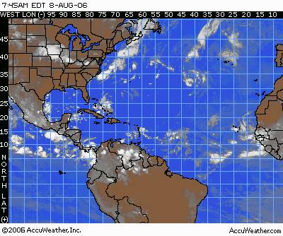
A tropical low pressure area about 1,075 miles east of the Windward Islands is moving to the west at about 6 degrees longitude per day. Satellite images showed a rotating mass of clouds with some thunderstorms growing within this mass. The center of this mass of clouds was roughly 12.0 north and 44.0 west. If thunderstorms continue to develop around this swirl of clouds, we could have a depression within the next 24-36 hours. A buoy located just northwest of the low continued to show falling pressure, suggesting this feature is trying to organize. Upper-level winds over this feature are not very strong. So, the shear over it is relatively light. Given the usual very warm water, this system is in a good position for development. In the coming days, as the low continues to track westward it would be in an area where the wind shear is less and thus the upper-level winds are more favorable for development. Current computer projections place this low pressure area in the Lesser Antilles Thursday night, then into the eastern Caribbean on Friday, but these models are showing little or no respect for this feature. All global models eventually show the system falling apart as it moves into the Lesser Antilles. An upper-level trough extending over the eastern Caribbean late in the week might create the shear that would prevent this system from developing further. So, speculating on this system beyond Friday is nearly impossible at this time.

Elsewhere in the tropical Atlantic we are tracking tropical waves along 28 west, 17 north and 73 west, 23 north and all south of 25 north. Both of these waves are moving west at an average speed of 6-7 degrees longitude per day. The wave near 73 west is interacting with an upper-level low near the eastern Bahamas. However, there is presently too much wind shear in this area and thus no further development is expected with this wave. It will bring an increase in moisture over South Florida on Wednesday, leading to more showers and thunderstorms.

Wednesday, August 02, 2006

Tropical Storm Chris Brings Rough Weather to the Virgin Islands

A tropical storm warning remains in effect for the islands of Anguilla, St. Bartholomew, St. Martin and St. Maarten.

A tropical storm warning is in effect for Puerto Rico, the U.S. Virgin Islands and the British Virgin Islands.

The tropical storm warning for St. Kitts, Nevis, Antigua, and Barbuda has been discontinued.

At 4:00 a.m. EDT, Tropical Storm Chris was still churning up the waters just to the northeast of the Leeward Islands. The storm was centered at 18.7 north, 62.5 west, 230 miles east of San Juan, Puerto Rico. The maximum winds were still 60 mph. The storm is moving west-northwest at around 9 mph and the minimum pressure was estimated to be 1002 millibars, or 29.59 inches of mercury. The tropical-storm-force winds extend outward up to 75 miles, mainly northeast from the storm's center. None of the observing sites in the Lesser Antilles are indicating any strong winds as of 5:00 a.m. EDT, though some are reporting weaker squalls associated with the storm. Being on the weaker side of the storm, most of the islands will probably only get tropical-storm-force winds in occasional gusts with the heaviest squalls. Rainfall amounts of 3-6 inches are possible over the Leeward Islands tonight and tomorrow and over the British Virgin Islands, the U.S. Virgin Islands and Puerto Rico tomorrow and tomorrow night. The mountains of Puerto Rico could help produce even more rainfall and perhaps dangerous mudslides if Chris comes close enough to that island tomorrow and tomorrow night.

Chris appears to be consolidating, becoming better organized, and gaining strength. The environment around the storm is favorable for further strengthening. The waters around the storm are warm and warm to substantial depth. The winds aloft are light, so there is little shear to be concerned with. The trend toward strengthening should continue in the near term, and Chris could easily be a hurricane by tonight or early Thursday morning

The track forecast and thus the long term intensity forecast is much more problematic. The consensus of the computer models is for Chris to take a track more westerly than northwesterly, and eventually rake the northern coasts of Puerto Rico and then Hispaniola. This would not be the best conditions for intensification, as a portion of the storms circulation would be interrupted by the high mountain terrain on those islands. However, the computer models have shown a bias forecasting storms too far left. Should the storm end up staying just far enough to the north of the islands, then it will remain more intense as it begins to affect Cuba and the Bahamas by the end of the week, and then possibly South Florida or the Keys late this weekend.

What is more certain at this point is that the Virgin Islands will experience squally conditions and gusty winds over the next 24 hours, and Puerto Rico will be brushed by strong winds by late Wednesday. The northern coast of Hispaniola will experience the strong winds by Friday. All of these areas will receive the heavy rains described above, and the rains could be even more extreme in Hispaniola should the storm take a more westward track. Therefore, storm preparations should be near completion in Puerto Rico and those residing in or those that have interests in Haiti or the Dominican Republic should rush storm preparations to completion at this point. Residents of Cuba and the southern Bahamas, as well as South Florida and the Keys need to monitor the storm's approach carefully. There is a good chance that Chris will be churning through the Gulf of Mexico next week.There are other features to track elsewhere in the tropics. There is a tropical wave in the Bay of Campeche along 92 west, south of 22 north. Although there is some thunderstorm activity along the wave, there is no sign of organization and development is unlikely before the wave is fully over Mexico. A wave along 70 west, south of 15 north is moving west at about 6 degrees longitude per day. This wave is mostly over land and is the southern part of the parent wave that was responsible for the formation of Tropical Storm Chris. There is another tropical wave along 36 west, south of 18 north, which is just to the west of the Cape Verde Islands. This wave is moving to the west at about 15 knots. There is no sign of organization with this wave at this point, but there is spotty thunderstorm activity. Finally, a new wave is over the African coastline at about 18 west, south of 21 north, zipping rapidly west at about 20 knots. There is widespread thunderstorm activity with this wave, but no sign of organization with it just yet.

Tuesday, August 01, 2006

Tropical Storm Chris Approaches the Lesser Antilles

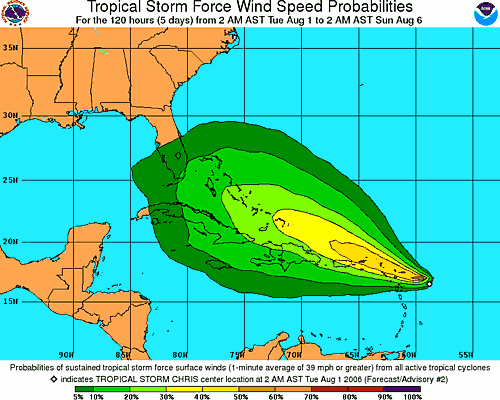
The area of disturbed weather that we have been tracking the past few days east of the Lesser Antilles has intensified into the third named storm of the season. As of 8am, Tropical Storm Chris was located near 16.8 north and 59.8 west or 135 miles east of Antigua. The storm is moving to the west-northwest at 9 mph with maximum sustained winds of 35 mph. The central pressure is estimated at 1009 millibars or 29.80 inches.

A tropical storm warning has been issued for the islands of Antigua, Barbuda, Anguilla, St. Kitts, Nevis, Saba, St. Eustatius, St. Barthelemy, St. Martin, and St. Maarten, while a tropical storm watch is now in effect for Puerto Rico, the U.S. Virgin Islands, and the British Virgin Islands.

Tropical Storm Chris will bring squally conditions to the Leeward Islands Tuesday and Wednesday. But, since it will be moving through the Leeward Islands, friction caused by the islands might prevent the depression from intensifying. Computer models continue to show a west northwest course which will keep the system over or near the Greater Antilles. This could further prevent intensification, and a large upper-level low north of the Bahamas may shear the storm later this week. If the system can avoid most of the islands, we project the system will be somewhere between the central Bahamas and southeast Cuba by Friday. This system could directly affect Florida early next week.

Elsewhere in the tropics we are tracking a wave along 29 west south of 18 north. This wave is moving west at about 6 degrees longitude per day. Dry air surrounds this well devleoped wave. As stated earlier some computer model output implies this system might develop in a few days.

A tropical wave along 87 west is moving west at about 7-8 degrees longitude per day. This wave has no organization, but the shear over it is rather low. Since there are no signs of a lower-level feature showing up yet, we do not expect this system to develop anytime soon.

Monday, July 31, 2006

Tropical Watch

A cluster of thunderstorms off the Carolina coast is associated with an old frontal zone and an upper-level trough. This feature will slowly shift offshore and it will take some time to develop.

A strung out tropical wave in the Caribbean is positioned from near 83 west and 15 north to near 73 west and 20 north. It is generally tracking west at 15 knots, although the eastern end of the wave is heading more to the northwest across Hispaniola. This wave is causing several showers and thunderstorms over this area with the heavier rainfall over Haiti into Jamaica and eastern Cuba. This system is becoming more and more elongated with time and will split with one piece moving northwest and the other moving due west. Development of either split looks unlikely, but the west moving system could gather some strength with low shear over the region.

We continue to track an impressive tropical wave centered near 55 west and 13 north. It is moving to the west-northwest at about 15 knots and has a center of circulation that can be seen on a visible satellite loop. It is causing plenty of thunderstorms near the center of circulation and looks like a tropical depression already. However, African Dust to the north of the wave and some east-northeast shear aloft may be keeping this feature from developing more robustly. Shear conditions will be less than favorable for the day, but could turn more favorable as the wave heads into the Caribbean. This wave has become less organized in the last 12 hours, but still contains moderate shower and thunderstorm activity. A robust tropical wave in the eastern Atlantic is located along 23 west and south of 12 north and it is moving west at 15-20 knots. This system will head into a little shear on the south side.

Thursday, July 27, 2006

Atlantic Quiet For Now

The area of disturbed weather that brought heavy rain to southeastern Texas and parts of Louisiana on Wednesday is now well inland. Moisture from this system will feed more showers and thunderstorms today through the southern Plains.

Elsewhere across the tropical Atlantic we are tracking tropical waves along 35 west, south of 15 north, along 46 west, south of 22 north, along 67 west, south of 24 north and along 84 west, south of 20 north. All waves with the exception of the wave along 64 west are moving west at about 6-7 degrees longitude per day.

The wave along 67 west is moving west at 8-10 degrees longitude per day as it starts to interact with the Atlantic high to the north. This high is producing a stronger pressure gradient over the Greater Antilles. This wave will bring the eastern and northeastern Caribbean a few showers and thunderstorms, but it is moving too fast to bring any prolonged rainfall. A large mass of African Dust showing up on both the United States and European satellite images of the Atlantic is causing any showers and thunderstorms with this wave to diminish quickly. This wave will bring showers into the southern Bahamas and Hispaniola tomorrow and tomorrow night, then might enhance shower and thunderstorm development over the northern Bahamas and perhaps into southeastern Florida, Friday night into Saturday morning.

Tuesday, July 25, 2006

Disturbed weather in the western Gulf of Mexico might become an organized tropical system

An area of disturbed weather in the western Gulf of Mexico is being watched for possible development within the next 24 to 36 hours. We are carefully monitoring a couple of low pressure areas along or just off the coast of Mexico just east and northeast of Tampico crawling northward toward the south Texas coast. This area of low pressure could be evolving into a tropical depression. As long as the low pressure areas stay near the coast frictional forces will slow and perhaps inhibit development. An upper level low over northeast Mexico is creating southwest upper level winds over the system. This is creating some shear over the feature and this is another inhibiting factor for development. We believe the shear being caused by the upper level low will decrease over the next 24 hours. If the shear diminishes enough and the surface low pressure moves a bit more off the coast then this feature could wrap up into an organized tropical system very quickly. Since the system is disorganized all the stronger winds and persistent heavy rainfall is well to the east and northeast, well offshore. In a system like this the heavier rainfall will remain north and east of the weak low pressure center. If the thunderstorms and rain start to wrap around the surface low pressure area that will be a sign of organization. We did not see that happen during Monday afternoon. Reguardless of whether this becomes better organized the system will bring heavy rainfall to parts of coastal Texas during the next 36 hours. We expect the surface low pressure area to track northward which will bring that feature just east of Brownsville by Tuesday morning then due east of Corpus Christi by late Tuesday afternoon. The surface low pressure area will move into east Texas during Wednesday. So, if it's going to organize and devleop it will have to do so by Wednesday morning.

Monday, July 24, 2006

Calm in the Atlantic, For Now

There is only one area of concern in the Atlantic basin. Thunderstorms are clustered in the Bay of Campeche in the wake of a tropical wave that has moved into Mexico. Currently, upper-level westerly winds are strong, shearing the thunderstorms apart and preventing further development. However, should the thunderstorms persist for another 24 hours, the upper-level winds should eventually relax and become more favorable for development as a ridge builds over the region. Whether or not development occurs, some of this moisture will be pulled northward into southern Texas tonight and Tuesday, resulting in heavy thunderstorms in those areas.
Another tropical wave is moving through the eastern Caribbean and is located along 79 west south of 20 north, moving west-northwest at 15 knots. There is very little thunderstorm activity along this wave.

Another couple of waves are progressing westward through the Atlantic. One wave is located along 67 west south of 18 north, moving west at 15 knots. There is little thunderstorm activity along this wave as well because of very dry air aloft over the region. The other wave has moved east of the Cape Verde Islands and is along 43 west south of 20 north. This wave has a well-defined low pressure area in association with it, but Saharan dust has become entrained with the system, choking off the thunderstorms that were along the wave earlier. So, development cannot occur along this wave anytime soon.

Friday, July 21, 2006

Tropical Storm Beryl hits Massachusetts

Tropical Storm Beryl quietly made landfall on Nantucket early Friday, bringing a steady, driving rain to coastal Massachusetts. Hours later, it moved out to sea, leaving little but a soaking in its path.

The storm's center hit around 3 a.m., said Jack Beven, hurricane specialist with the National Hurricane Center in Miami.

The wind and rain started to pick up just after midnight, said Rocky Fox, owner of the Chicken Box bar there. But he wasn't scared: "It's the kind that puddles quick," he said. "To us it's just a big old Nor'easter."

Officials said the region fared well. The Coast Guard said they hadn't heard of problems, and no power outages were reported.

"It looks like a gray, rainy day," said Nantucket Fire Department Capt. Steve Murphy as he looked out the window.

A tropical storm warning issued from the coast of Massachusetts was discontinued Friday morning, according to the National Hurricane Center in Miami. Areas affected included Cape Cod, Nantucket and Martha's Vineyard.

At 5 a.m. EDT, the storm had maximum sustained winds of about 50 mph, and was about 35 miles northeast of Nantucket. It was expected to weaken over the next 24 hours and lose tropical characteristics by Saturday morning.

It was moving at about 21 mph and was expected to increase in speed Friday, forecasters said. The center of Beryl was expected to be near or over Nova Scotia late Friday or early Saturday.

The Coast Guard was monitoring about 50 commercial fishing vessels still on the New England waters near the storm's path late Thursday night, but had no reports of vessels in trouble, said Chief Petty Officer Scott Carr.A tropical storm watch had been issued for eastern Long Island and parts of Connecticut, but was discontinued early Friday as the storm moved northeast.

A tropical storm watch had been issued for eastern Long Island and parts of Connecticut, but was discontinued early Friday as the storm moved northeast.


Workers at Nantucket Moorings on Thursday were making sure their customers' boats were tied down securely, but they weren't panicking.


"That's all we can do for now — make sure lines are secure and people know that the storm is approaching," said Leigh Van Hoven, office manager of the company, which rents and sells moorings.


A record 28 named storms and 15 hurricanes, including destructive Katrina, occurred during last year's June-November Atlantic hurricane season.
The first named storm of the 2006 season, Tropical Storm Alberto, swept over Florida in mid-June, then plowed northward along the coast past the Outer Banks. It was blamed for one drowning.

Thursday, July 20, 2006

Beryl Moving Northward Just off Delmarvia Coastline Thursday

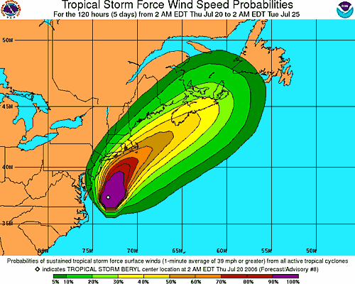
A tropical storm warning has been issued for southeastern Massachusetts from Plymouth, southward and westward to Woods Hole. This includes Cape Cod, Nantucket Island and Martha's Vineyard. Additional watches and warnings may be necessary for parts of Long Island and the New England coastline.

Tropical Storm Beryl is about 295 miles south of Nantucket, Massachusetts, packing winds of 60 mph with gusts to 70 mph. As of 5:00 a.m. EDT Thursday, the center of Beryl was located near 37.8 north and 73.2 west. The storm is moving generally to the north at 9 mph. The surface pressure remains at 1002 millibars, or 29.59 inches. Beryl will continue on a northerly track and will increase in forward speed over the next 24 hours. The shear should increase Thursday morning as an upper-level trough approaches from the west, and will help to prevent any significant intensification Thursday. Also, Beryl will be moving over some cooler waters as it continues to head to the north. It should remain a very strong tropical storm through Thursday afternoon as it moves faster and on more of a northeasterly course. The increased shear will then cause the storm to weaken late Thursday and Thursday night. Our forecast will bring the center of Beryl over or near Nantucket early Friday morning. The system should track to the northeast of southeastern New England by later Friday morning and will start to transition to a non-tropical system as it approaches southern Nova Scotia Friday afternoon. Strong winds should continue to stay offshore until the storm moves close to eastern Long Island and over extreme southeastern New England later Thursday night and early Friday morning. We are expecting 15-30 mph winds with gusts to 40 mph along far eastern Long Island and extreme coastal New England. Places like Block Island and Nantucket Island could have higher wind gusts.

The greatest threat with Beryl will be rough surf and rip currents. All the way from Cape Cod southward to Cape Lookout, there will be an increased threat of rip currents. Swimmers and surfers are urged to use extreme caution or even avoid entering the surf through Friday, as rip currents can drown even the best swimmers.

Wednesday, July 19, 2006

Tropical Storm Beryl Moving North Offshore North Carolina

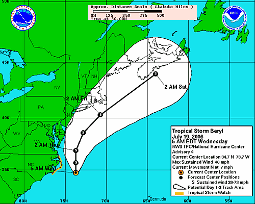
Tropical Storm Beryl is located 110 miles east-southeast of Cape Hatteras, North Carolina. Beryl continues on a northerly track at 7 mph and maintain tropical storm strength over the next 24 to 48 hours. The storm will track northward, grazing the Outer Banks of North Carolina today. Based on this track, eastern North Carolina and perhaps southeastern Virginia and the Delmarva Peninsula would see some rain squalls with gusty winds tonight, and early Thursday before the storm accelerates northeastward with similar conditions around Cape Cod on Friday.

A tropical storm watch remains in effect for the North Carolina coast from north of Cape Lookout to south of Currituck Beach Light.

Residents of the Outer Banks of North Carolina should be completed with storm preparations at this point, as this area will at least be brushed by Beryl. Those along the coast all the way to Cape Cod should keep a close watch on Beryl's progress, as any deviation west of the forecast track would result in areas around the coast to be directly affected. Outside of the main danger area, Beryl will cause rip currents, rough surf and some beach erosion, as well as possible coastal flooding along the Carolina and mid-Atlantic coasts.

Elsewhere in the Atlantic, there are a few tropical waves to follow. One tropical wave is moving across the Yucatan Peninsula and will eventually move over the Bay of Campeche Wednesday. The close proximity to land should prevent further organization or strengthening

Another tropical wave is along 68 west, south of 25 north. It is causing thunderstorms over the eastern Caribbean.

A third tropical wave in the open Atlantic, near 35 west, south of 16 north. There could be development along this wave over time as well, since the waters are progressively warmer in the path of the wave and there is no significant shear in the region.