Wednesday, August 02, 2006

Tropical Storm Chris Brings Rough Weather to the Virgin Islands

A tropical storm warning remains in effect for the islands of Anguilla, St. Bartholomew, St. Martin and St. Maarten.

A tropical storm warning is in effect for Puerto Rico, the U.S. Virgin Islands and the British Virgin Islands.

The tropical storm warning for St. Kitts, Nevis, Antigua, and Barbuda has been discontinued.

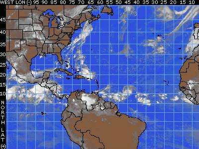
At 4:00 a.m. EDT, Tropical Storm Chris was still churning up the waters just to the northeast of the Leeward Islands. The storm was centered at 18.7 north, 62.5 west, 230 miles east of San Juan, Puerto Rico. The maximum winds were still 60 mph. The storm is moving west-northwest at around 9 mph and the minimum pressure was estimated to be 1002 millibars, or 29.59 inches of mercury. The tropical-storm-force winds extend outward up to 75 miles, mainly northeast from the storm's center. None of the observing sites in the Lesser Antilles are indicating any strong winds as of 5:00 a.m. EDT, though some are reporting weaker squalls associated with the storm. Being on the weaker side of the storm, most of the islands will probably only get tropical-storm-force winds in occasional gusts with the heaviest squalls. Rainfall amounts of 3-6 inches are possible over the Leeward Islands tonight and tomorrow and over the British Virgin Islands, the U.S. Virgin Islands and Puerto Rico tomorrow and tomorrow night. The mountains of Puerto Rico could help produce even more rainfall and perhaps dangerous mudslides if Chris comes close enough to that island tomorrow and tomorrow night.

Chris appears to be consolidating, becoming better organized, and gaining strength. The environment around the storm is favorable for further strengthening. The waters around the storm are warm and warm to substantial depth. The winds aloft are light, so there is little shear to be concerned with. The trend toward strengthening should continue in the near term, and Chris could easily be a hurricane by tonight or early Thursday morning

The track forecast and thus the long term intensity forecast is much more problematic. The consensus of the computer models is for Chris to take a track more westerly than northwesterly, and eventually rake the northern coasts of Puerto Rico and then Hispaniola. This would not be the best conditions for intensification, as a portion of the storms circulation would be interrupted by the high mountain terrain on those islands. However, the computer models have shown a bias forecasting storms too far left. Should the storm end up staying just far enough to the north of the islands, then it will remain more intense as it begins to affect Cuba and the Bahamas by the end of the week, and then possibly South Florida or the Keys late this weekend.

What is more certain at this point is that the Virgin Islands will experience squally conditions and gusty winds over the next 24 hours, and Puerto Rico will be brushed by strong winds by late Wednesday. The northern coast of Hispaniola will experience the strong winds by Friday. All of these areas will receive the heavy rains described above, and the rains could be even more extreme in Hispaniola should the storm take a more westward track. Therefore, storm preparations should be near completion in Puerto Rico and those residing in or those that have interests in Haiti or the Dominican Republic should rush storm preparations to completion at this point. Residents of Cuba and the southern Bahamas, as well as South Florida and the Keys need to monitor the storm's approach carefully. There is a good chance that Chris will be churning through the Gulf of Mexico next week.There are other features to track elsewhere in the tropics. There is a tropical wave in the Bay of Campeche along 92 west, south of 22 north. Although there is some thunderstorm activity along the wave, there is no sign of organization and development is unlikely before the wave is fully over Mexico. A wave along 70 west, south of 15 north is moving west at about 6 degrees longitude per day. This wave is mostly over land and is the southern part of the parent wave that was responsible for the formation of Tropical Storm Chris. There is another tropical wave along 36 west, south of 18 north, which is just to the west of the Cape Verde Islands. This wave is moving to the west at about 15 knots. There is no sign of organization with this wave at this point, but there is spotty thunderstorm activity. Finally, a new wave is over the African coastline at about 18 west, south of 21 north, zipping rapidly west at about 20 knots. There is widespread thunderstorm activity with this wave, but no sign of organization with it just yet.
Tuesday, August 01, 2006

Tropical Storm Chris Approaches the Lesser Antilles

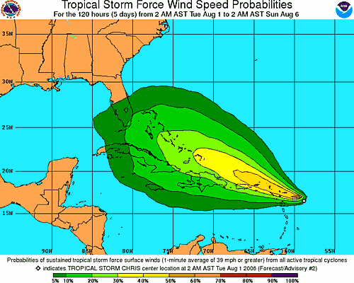
The area of disturbed weather that we have been tracking the past few days east of the Lesser Antilles has intensified into the third named storm of the season. As of 8am, Tropical Storm Chris was located near 16.8 north and 59.8 west or 135 miles east of Antigua. The storm is moving to the west-northwest at 9 mph with maximum sustained winds of 35 mph. The central pressure is estimated at 1009 millibars or 29.80 inches.

A tropical storm warning has been issued for the islands of Antigua, Barbuda, Anguilla, St. Kitts, Nevis, Saba, St. Eustatius, St. Barthelemy, St. Martin, and St. Maarten, while a tropical storm watch is now in effect for Puerto Rico, the U.S. Virgin Islands, and the British Virgin Islands.

Tropical Storm Chris will bring squally conditions to the Leeward Islands Tuesday and Wednesday. But, since it will be moving through the Leeward Islands, friction caused by the islands might prevent the depression from intensifying. Computer models continue to show a west northwest course which will keep the system over or near the Greater Antilles. This could further prevent intensification, and a large upper-level low north of the Bahamas may shear the storm later this week. If the system can avoid most of the islands, we project the system will be somewhere between the central Bahamas and southeast Cuba by Friday. This system could directly affect Florida early next week.

Elsewhere in the tropics we are tracking a wave along 29 west south of 18 north. This wave is moving west at about 6 degrees longitude per day. Dry air surrounds this well devleoped wave. As stated earlier some computer model output implies this system might develop in a few days.

A tropical wave along 87 west is moving west at about 7-8 degrees longitude per day. This wave has no organization, but the shear over it is rather low. Since there are no signs of a lower-level feature showing up yet, we do not expect this system to develop anytime soon.

Monday, July 31, 2006

Tropical Watch

A cluster of thunderstorms off the Carolina coast is associated with an old frontal zone and an upper-level trough. This feature will slowly shift offshore and it will take some time to develop.

A strung out tropical wave in the Caribbean is positioned from near 83 west and 15 north to near 73 west and 20 north. It is generally tracking west at 15 knots, although the eastern end of the wave is heading more to the northwest across Hispaniola. This wave is causing several showers and thunderstorms over this area with the heavier rainfall over Haiti into Jamaica and eastern Cuba. This system is becoming more and more elongated with time and will split with one piece moving northwest and the other moving due west. Development of either split looks unlikely, but the west moving system could gather some strength with low shear over the region.

We continue to track an impressive tropical wave centered near 55 west and 13 north. It is moving to the west-northwest at about 15 knots and has a center of circulation that can be seen on a visible satellite loop. It is causing plenty of thunderstorms near the center of circulation and looks like a tropical depression already. However, African Dust to the north of the wave and some east-northeast shear aloft may be keeping this feature from developing more robustly. Shear conditions will be less than favorable for the day, but could turn more favorable as the wave heads into the Caribbean. This wave has become less organized in the last 12 hours, but still contains moderate shower and thunderstorm activity. A robust tropical wave in the eastern Atlantic is located along 23 west and south of 12 north and it is moving west at 15-20 knots. This system will head into a little shear on the south side.

Thursday, July 27, 2006

Atlantic Quiet For Now

The area of disturbed weather that brought heavy rain to southeastern Texas and parts of Louisiana on Wednesday is now well inland. Moisture from this system will feed more showers and thunderstorms today through the southern Plains.

Elsewhere across the tropical Atlantic we are tracking tropical waves along 35 west, south of 15 north, along 46 west, south of 22 north, along 67 west, south of 24 north and along 84 west, south of 20 north. All waves with the exception of the wave along 64 west are moving west at about 6-7 degrees longitude per day.

The wave along 67 west is moving west at 8-10 degrees longitude per day as it starts to interact with the Atlantic high to the north. This high is producing a stronger pressure gradient over the Greater Antilles. This wave will bring the eastern and northeastern Caribbean a few showers and thunderstorms, but it is moving too fast to bring any prolonged rainfall. A large mass of African Dust showing up on both the United States and European satellite images of the Atlantic is causing any showers and thunderstorms with this wave to diminish quickly. This wave will bring showers into the southern Bahamas and Hispaniola tomorrow and tomorrow night, then might enhance shower and thunderstorm development over the northern Bahamas and perhaps into southeastern Florida, Friday night into Saturday morning.

Tuesday, July 25, 2006

Disturbed weather in the western Gulf of Mexico might become an organized tropical system

An area of disturbed weather in the western Gulf of Mexico is being watched for possible development within the next 24 to 36 hours. We are carefully monitoring a couple of low pressure areas along or just off the coast of Mexico just east and northeast of Tampico crawling northward toward the south Texas coast. This area of low pressure could be evolving into a tropical depression. As long as the low pressure areas stay near the coast frictional forces will slow and perhaps inhibit development. An upper level low over northeast Mexico is creating southwest upper level winds over the system. This is creating some shear over the feature and this is another inhibiting factor for development. We believe the shear being caused by the upper level low will decrease over the next 24 hours. If the shear diminishes enough and the surface low pressure moves a bit more off the coast then this feature could wrap up into an organized tropical system very quickly. Since the system is disorganized all the stronger winds and persistent heavy rainfall is well to the east and northeast, well offshore. In a system like this the heavier rainfall will remain north and east of the weak low pressure center. If the thunderstorms and rain start to wrap around the surface low pressure area that will be a sign of organization. We did not see that happen during Monday afternoon. Reguardless of whether this becomes better organized the system will bring heavy rainfall to parts of coastal Texas during the next 36 hours. We expect the surface low pressure area to track northward which will bring that feature just east of Brownsville by Tuesday morning then due east of Corpus Christi by late Tuesday afternoon. The surface low pressure area will move into east Texas during Wednesday. So, if it's going to organize and devleop it will have to do so by Wednesday morning.

Monday, July 24, 2006

Calm in the Atlantic, For Now

There is only one area of concern in the Atlantic basin. Thunderstorms are clustered in the Bay of Campeche in the wake of a tropical wave that has moved into Mexico. Currently, upper-level westerly winds are strong, shearing the thunderstorms apart and preventing further development. However, should the thunderstorms persist for another 24 hours, the upper-level winds should eventually relax and become more favorable for development as a ridge builds over the region. Whether or not development occurs, some of this moisture will be pulled northward into southern Texas tonight and Tuesday, resulting in heavy thunderstorms in those areas.
Another tropical wave is moving through the eastern Caribbean and is located along 79 west south of 20 north, moving west-northwest at 15 knots. There is very little thunderstorm activity along this wave.

Another couple of waves are progressing westward through the Atlantic. One wave is located along 67 west south of 18 north, moving west at 15 knots. There is little thunderstorm activity along this wave as well because of very dry air aloft over the region. The other wave has moved east of the Cape Verde Islands and is along 43 west south of 20 north. This wave has a well-defined low pressure area in association with it, but Saharan dust has become entrained with the system, choking off the thunderstorms that were along the wave earlier. So, development cannot occur along this wave anytime soon.

Friday, July 21, 2006

Tropical Storm Beryl hits Massachusetts

Tropical Storm Beryl quietly made landfall on Nantucket early Friday, bringing a steady, driving rain to coastal Massachusetts. Hours later, it moved out to sea, leaving little but a soaking in its path.

The storm's center hit around 3 a.m., said Jack Beven, hurricane specialist with the National Hurricane Center in Miami.

The wind and rain started to pick up just after midnight, said Rocky Fox, owner of the Chicken Box bar there. But he wasn't scared: "It's the kind that puddles quick," he said. "To us it's just a big old Nor'easter."

Officials said the region fared well. The Coast Guard said they hadn't heard of problems, and no power outages were reported.

"It looks like a gray, rainy day," said Nantucket Fire Department Capt. Steve Murphy as he looked out the window.

A tropical storm warning issued from the coast of Massachusetts was discontinued Friday morning, according to the National Hurricane Center in Miami. Areas affected included Cape Cod, Nantucket and Martha's Vineyard.

At 5 a.m. EDT, the storm had maximum sustained winds of about 50 mph, and was about 35 miles northeast of Nantucket. It was expected to weaken over the next 24 hours and lose tropical characteristics by Saturday morning.

It was moving at about 21 mph and was expected to increase in speed Friday, forecasters said. The center of Beryl was expected to be near or over Nova Scotia late Friday or early Saturday.

The Coast Guard was monitoring about 50 commercial fishing vessels still on the New England waters near the storm's path late Thursday night, but had no reports of vessels in trouble, said Chief Petty Officer Scott Carr.A tropical storm watch had been issued for eastern Long Island and parts of Connecticut, but was discontinued early Friday as the storm moved northeast.

A tropical storm watch had been issued for eastern Long Island and parts of Connecticut, but was discontinued early Friday as the storm moved northeast.


Workers at Nantucket Moorings on Thursday were making sure their customers' boats were tied down securely, but they weren't panicking.


"That's all we can do for now — make sure lines are secure and people know that the storm is approaching," said Leigh Van Hoven, office manager of the company, which rents and sells moorings.


A record 28 named storms and 15 hurricanes, including destructive Katrina, occurred during last year's June-November Atlantic hurricane season.
The first named storm of the 2006 season, Tropical Storm Alberto, swept over Florida in mid-June, then plowed northward along the coast past the Outer Banks. It was blamed for one drowning.

Thursday, July 20, 2006

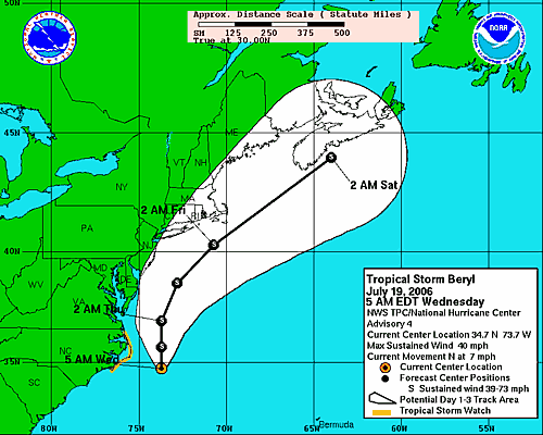
Beryl Moving Northward Just off Delmarvia Coastline Thursday

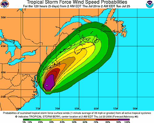
A tropical storm warning has been issued for southeastern Massachusetts from Plymouth, southward and westward to Woods Hole. This includes Cape Cod, Nantucket Island and Martha's Vineyard. Additional watches and warnings may be necessary for parts of Long Island and the New England coastline.

Tropical Storm Beryl is about 295 miles south of Nantucket, Massachusetts, packing winds of 60 mph with gusts to 70 mph. As of 5:00 a.m. EDT Thursday, the center of Beryl was located near 37.8 north and 73.2 west. The storm is moving generally to the north at 9 mph. The surface pressure remains at 1002 millibars, or 29.59 inches. Beryl will continue on a northerly track and will increase in forward speed over the next 24 hours. The shear should increase Thursday morning as an upper-level trough approaches from the west, and will help to prevent any significant intensification Thursday. Also, Beryl will be moving over some cooler waters as it continues to head to the north. It should remain a very strong tropical storm through Thursday afternoon as it moves faster and on more of a northeasterly course. The increased shear will then cause the storm to weaken late Thursday and Thursday night. Our forecast will bring the center of Beryl over or near Nantucket early Friday morning. The system should track to the northeast of southeastern New England by later Friday morning and will start to transition to a non-tropical system as it approaches southern Nova Scotia Friday afternoon. Strong winds should continue to stay offshore until the storm moves close to eastern Long Island and over extreme southeastern New England later Thursday night and early Friday morning. We are expecting 15-30 mph winds with gusts to 40 mph along far eastern Long Island and extreme coastal New England. Places like Block Island and Nantucket Island could have higher wind gusts.

The greatest threat with Beryl will be rough surf and rip currents. All the way from Cape Cod southward to Cape Lookout, there will be an increased threat of rip currents. Swimmers and surfers are urged to use extreme caution or even avoid entering the surf through Friday, as rip currents can drown even the best swimmers.

Wednesday, July 19, 2006

Tropical Storm Beryl Moving North Offshore North Carolina

Tropical Storm Beryl is located 110 miles east-southeast of Cape Hatteras, North Carolina. Beryl continues on a northerly track at 7 mph and maintain tropical storm strength over the next 24 to 48 hours. The storm will track northward, grazing the Outer Banks of North Carolina today. Based on this track, eastern North Carolina and perhaps southeastern Virginia and the Delmarva Peninsula would see some rain squalls with gusty winds tonight, and early Thursday before the storm accelerates northeastward with similar conditions around Cape Cod on Friday.

A tropical storm watch remains in effect for the North Carolina coast from north of Cape Lookout to south of Currituck Beach Light.

Residents of the Outer Banks of North Carolina should be completed with storm preparations at this point, as this area will at least be brushed by Beryl. Those along the coast all the way to Cape Cod should keep a close watch on Beryl's progress, as any deviation west of the forecast track would result in areas around the coast to be directly affected. Outside of the main danger area, Beryl will cause rip currents, rough surf and some beach erosion, as well as possible coastal flooding along the Carolina and mid-Atlantic coasts.

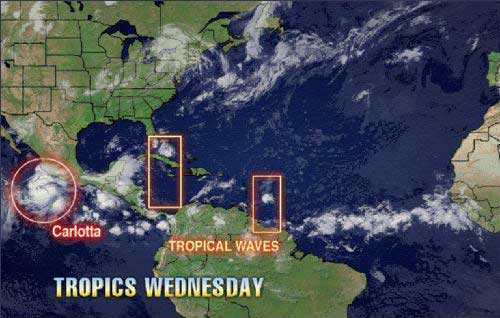
Elsewhere in the Atlantic, there are a few tropical waves to follow. One tropical wave is moving across the Yucatan Peninsula and will eventually move over the Bay of Campeche Wednesday. The close proximity to land should prevent further organization or strengthening

Another tropical wave is along 68 west, south of 25 north. It is causing thunderstorms over the eastern Caribbean.

A third tropical wave in the open Atlantic, near 35 west, south of 16 north. There could be development along this wave over time as well, since the waters are progressively warmer in the path of the wave and there is no significant shear in the region.

Monday, July 17, 2006

Fast Flood Facts from FloodSmart.gov

Did you know?
• Floods and flash floods happen in all 50 states.
• Everyone lives in a flood zone. (For more information, visit the Frequently Asked Questions about Flood Zones)
• Most homeowners insurance does not cover flood damage.
• If you live in a Special Flood Hazard Area (SFHA) or high risk area, your mortgage lender requires you to have flood insurance. (To find out if you are in an SFHA, visit What's Your Flood Risk?)
• Just an inch of water can cause costly damage to your property.
• Flash floods often bring walls of water 10 to 20 feet high.
• A car can easily be carried away by just two feet of floodwater.
• Hurricanes, winter storms and snow melt are common (but often overlooked) causes of flooding.
• New land development can increase flood risk, especially if the construction changes natural runoff paths.
• Federal disaster assistance is usually a loan that must be paid back with interest. For a $50,000 loan at 4% interest, your monthly payment would be around $240 a month ($2,880 a year) for 30 years. Compare that to a $100,000 flood insurance premium, which is about $500 a year ($33 a month).
• If you live in a low to moderate risk area and are eligible for the Preferred Risk Policy, your flood insurance premium may be as low as $112 a year, including coverage for your property's contents.
• You are eligible to purchase flood insurance as long as your community participates in the National Flood Insurance Program. Check the Community Status Book to see if your community is already an NFIP partner.
It takes 30 days after purchase for a policy to take effect, so it's important to buy insurance before the floodwaters start to rise.
• All claims and expenses of the NFIP program are funded by insurance premiums, not tax dollars.

Friday, July 14, 2006

Making Waves

The next tropical wave to be concerned with is roughly along 70 west, south of 20 north. It is moving west-northwestward at about 15 knots. There are no signs of organization with this wave at the moment and shear caused by westerly winds aloft will prevent any development along this wave in the near future. The wave is causing showers and thunderstorms in Puerto Rico and the Virgin Islands Thursday night that will reach Hispaniola Friday. This wave will eventually reach South Florida by Sunday.

A weak wave is around 54 west, south of 12 north. There are a few scattered showers from this system, but no development is expected.

Another tropical wave is out over the open Atlantic to the southwest of the Cape Verde Islands along 30 west, south of 15 north. There appears to be an area of low pressure along this wave centered near 27 west and 13 north, as evidenced by a swirl of clouds on satellite pictures of the region. While in minimal shear at this point it will continue to head toward a region where more shear is expected. Development is not expected.

Another wave is moving through western Africa and should form another Atlantic tropical wave later Friday.

Wednesday, July 12, 2006

A Tropical Wave East of the Lesser Antilles Might Have Favorable Conditions for Development in a Few Days


We are tracking tropical waves along 74 west and along 53 west. The wave along 74 west extends to about 21 north and is moving to the west at 10-15 knots or about 6 degrees longitude per day. This wave is causing an increase in clouds, showers and thunderstorms over the Bahamas and eastern Cuba, as well as parts of Columbia. That wave will help bring a moisture surge into South and central Florida Wednesday and Thursday. A large area of dry air follows this wave over the Leeward Islands.

The wave along 53 west has a curved cloud structure that extends up to about 15 north with a 1012 mb low associated with it. This wave is moving westward at about 6 degrees longitude per day. Microwave satellite images show clusters of thunderstorms and a slight rotary motion in the thunderstorm pattern. This is often the beginning sign of a possible low-level or upper-level feature forming. For the first time this tropical season, the shear has relaxed over the Lesser Antilles and the eastern Caribbean. Current shear in the path of this wave is generally less than 10 knots and that is not enough to kill the wave. Another problem with this season thus far has been higher-than-normal surface pressures over the Caribbean. Current surface data indicates that surface pressures are lower today compared to last week and are near normal for the most part. If surface pressure continues to lower and the shear continues to relax over the eastern Caribbean and near the Lesser Antilles, this wave could try to organize in a few days. This wave will move into the Lesser Antilles Wednesday night and Thursday.

Monday, July 10, 2006

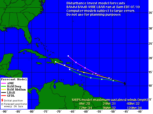
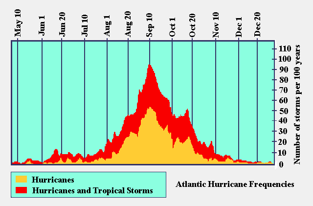
Model forecast tracks / A normal July

Model forecast tracks for the tropical wave approaching the Lesser Antilles Islands.

The curve of historical normal hurricane activity of the Atlantic Ocean.

Tropical Development Unlikely

A tropical wave is causing a few showers and thunderstorms from Puerto Rico to just north of the Dominican Republic and northward still into the Bahamas. While there is considerable convection with this wave, there will be little organized storminess at this point. These thunderstorms have been ongoing for the past 24 hours, but tropical development is unlikely over the coming days due to wind shear and stronger-than-average surface pressures in their path. This disturbance should reach Florida by Wednesday, causing an increase in thunderstorm activity.

Another tropical wave is located near 44/45 west, south of 15 north and is moving to the west at 15 knots. Thunderstorms have become better organized with the wave, and a small surface low with a minimum pressure of 1012 mb has developed. This wave shows small promise for future development, but it will also be entering an area of some wind shear near the Leeward Islands.

Friday, July 07, 2006

Disturbed weather in the northwest Caribbean is being watched

An upper level system, extending from near Florida toward the southwest across the southeast Gulf of Mexico and into the northwest Caribbean Sea, continues to generate showers and thunderstorms from the U.S. southeast coast southwest into the northwest Caribbean. A surface low will devleop along a weak front moving into the southeast U.S. and become better developed near the Carolina coast later today and Saturday then lift northeast. We see no tropical development with this low. However, a tropical wave along 85 west near 22 north angles back south southwest into the northwest Caribbean. This tropical wave is interacting with the upper level system and this is leading to enhanced thunderstorms from western Cuba southward into eastern Nicarague and Honduras. Surface pressures in this area remain too high for possible development within the next couple of days and the wave is moving westward at about 7 to 8 degrees longitude per day. So, this feature will be over the Yucatan tomorrow, slow down and move into the southwest Gulf Saturday night and Sunday. There is a slight chance this system could organize in the far southwest Gulf of Mexico on Sunday.

Elsewhere in the Atlantic Basin a tropical waves along 60 west and along 45 west are moving west at about 15kts. Both waves are surrounded by African dust at this time. This dust will continue to suppress thunderstorm development in and around these tropical waves. A new wave is emerging off the African coast just east of 20 west. t too is surrounded by dust and the thunderstorms around it will probably diminish witin the next 24 hours as it heads west.

A large area of African dust covers the eastern Caribbean eastward across the tropical Atlantic. As we have been stating all week this large area of dust is creating a strong inversion which will continue to suppress convective development. Given no large scale shower and thunderstorm development it will be very difficult for any tropical development over the eastern Caribbean into the western tropical Atlantic for the next few days.

Thursday, July 06, 2006

Tropical Atlantic remains quiet

The Atlantic Basin continues to look fairly quiet. We continue to monitor an area of clouds, showers and thunderstorms over the northern Bahamas into southeast Florida. This area of disturbed weather is associated with a weak upper level low that is centered near Miami Florida. This upper level feature will move west northwest over the next 24 hours then become oval shaped and oriented northeast to southwest on Friday as an upper level system moves into the Southeast U.S.. A weak cool front supported by this upper level system dropping into the Southeast U.S. will reach northern Florida tomorrow night. This very complex weather pattern will cause a surface low to form over southeast Georgia tomorrow night. That low pressure are will move northeast close to the South and North Carolina coast during Friday and Friday night. This will not be a tropical feature at this point. However, it could become a non tropical storm system as it moves northeast Friday night and Saturday.

Elsewhere in the tropics we are monitoring tropical waves along 76 west south of 22 north, along 52 west south of 11 north and along 35 west south of 13 north. These waves are moving to the west at about 15-20 knots or about 7 degrees longitude per day. The wave along 76 west is enhancing thunderstorm development over eastern Cuba and over the southern Caribbean. But there is little shower or thunderstorm development over the middle Caribbean. We expect this wave to be along 82 west late tomorrow and near 90 west by Friday evening. This will help produce an increase in thunderstorms over the Yucatan peninsula during Friday. This wave might be something to watch over the weekend as it moves into the Bay of Campeche or the southwest Gulf of Mexico.

Wednesday, July 05, 2006

Florida coral battered by hurricanes and disease

DRY TORTUGAS NATIONAL PARK, Florida (Reuters) - In the azure waters of Florida's remote Dry Tortugas National Park, corals have been toppled by hurricanes and blighted by disease and a phenomenon known as bleaching.

Eight hurricanes in two years and a plague of disease that swept the Caribbean recently have damaged the colorful, thick carpets of open-water coral reefs in the 100-square-mile (260-sq-km) park off Florida's southwest coast.

With another hurricane season under way and diseases such as white plague getting an early start this year, scientists surveying the reef expressed heightened concern for the fragile corals, which are important nurseries and habitats for marine life and harbingers of the health of the seas.

"There are some areas out here that are like a parking lot, absolutely denuded," said Dr. Jerry Ault, associate professor of marine biology and fisheries at the University of Miami's Rosenstiel School of Marine & Atmospheric Science.

Ault supervised a team of nearly 40 divers aboard the 100-foot (30-meter) research vessel Spree recently as they conducted a three-week, $300,000 biennial census, surveying coral, fish and lobster.

The Dry Tortugas are a cluster of seven tiny islands and acres (hectares) of coral seabed located 70 miles southwest of Key West, a popular tourist island at the southern tip of the Florida peninsula.

"Since 2004, we have had eight storms that have tracked within 100 miles of the Tortugas," said Ault. "In 2005, this was ground zero for major storms.

"Are we afraid of another hurricane season? Three (bad) hurricane seasons can't be a good thing."

"Coral reefs are in a state of decline around the world," said Billy Causey, acting regional manager for national marine sanctuaries in the southeast United States. "At least we have protections in place. There's probably not a piece of coral reef real estate that is any more protected."

The Tropical Atlantic remains relatively quiet

The upper level low just east of Florida and a tropical wave along 70 west are our main concerns for any possible tropical development. At this point we don either system within the next couple of days due to strong shear and higher than normal surface pressure. The wave along 70 west is handled differently by various computer models. There is some attempt by one model to show some organization of this wave within the next 3 days. However, we don't see that on other model output. A large area of African dust that we have been stating over the past few days continues to advance westward and is now entering the eastern Caribbean. This African dust represents drier than normal air at about 10,000 feet. This tends to put a lid on thunderstorm development. This drier air is feeding into the back of the wave along 70 west and this will also hinder development.

We are tracking other tropical waves. They are along: 30 west south of 15 north, along 45 west south of 15 north and along 85 west south of 13 north. These tropical waves are moving west at 15-20 knots or about 7 degrees longitude per day. We see no support for any development by any of these waves.

Looking back a year ago for July 4-5 we had two tropical depressions one became Cindy and the other was Dennis. We have had only one tropical cyclone so far this season and this is much closer to a near normal season. We believe the reason we have not seen any quick development like last year is due to several factors. As stated above we are seeing surface pressures a bit higher than normal over the Caribbean compared to lower than normal last year. We also continue to see strong shearing over the eastern Gulf of Mexico down into the Caribbean due to frequent upper level troughs forming over the eastern U.S.. through the Caribbean. Current trends in longer range computer output suggests these conditions should persist through the next 5-7 days and perhaps longer.

Friday, June 30, 2006

Tropical Wave Impacting the Bay of Campeche

A tropical wave along 98 west and south of 20 north is flaring up showers and thunderstorms across the Bay of Campeche. This feature is looking better organized, according to the latest satellite loop, with a large, somewhat concentrated, area of deep convection. However, westerly winds aloft are too strong to allow for fast development or falling pressure. The wave is tracking to the west-northwest at 10-15 knots and will bring beneficial showers and thunderstorms to South Texas over the weekend. If this feature persists for a couple of days and becomes a depression, it could cause flooding rains over eastern Mexico.

A potent tropical wave continues to affect the eastern Caribbean. It is located along 72 west and south of 20 north and is moving west-northwest at 15-20 knots. The wave is causing numerous showers and thunderstorms from Puerto Rico to the Leeward Islands, with a large area of deep convection north of Hispaniola. This convection is being aided by a broad upper-level trough, which is causing southwesterly shear over the system, actually aiding in thunderstorm development much like upper-level shear over the Plains during spring. However, this shear will not allow for tropical development, even though the upper-level trough will move back to the west over the next couple of days, as will the shear, but the wave should continue to track under the shear, slowing the development. Tropical moisture from this wave should increase the chance of showers and thunderstorms across central and South Florida later in the weekend.

Farther east, another tropical wave is located along 54 west and south of 10 north. It is moving west at 15-20 knots and shows little sign of organization. Our last tropical wave is along 38 west and south of 10 north and shows little sign of development.

Thursday, June 29, 2006

Tropical Wave Lashes Lesser Antilles and the Virgin Islands

A robust tropical wave continues to produce squally conditions across the Lesser Antilles Thursday. The wave, along 63 west and south of 20 north, is tracking to the west at 15 knots and will move into the western Caribbean later this weekend. It will bring gusty winds and numerous showers and thunderstorms to Puerto Rico today and then Hispaniola on Friday. An upper-level trough is causing a southwest shear across the eastern Caribbean and over the top of this wave so any development will be slow for the time being. The upper-level trough will back to the west over the next couple of days and so will the shear, but if the wave continues to track under the shear, then development will continue to be slow. Tropical moisture from this wave should increase the chance of showers and thunderstorms across central and South Florida later in the weekend.

Another tropical wave along 96 west and south of 20 north is moving west at 10-15 knots, but convection associated with it has greatly diminished. Moisture from this wave will bring much-needed showers and thunderstorms to South Texas over the weekend.

Farther east, another tropical wave is located along 47 west and south of 10 north. It is moving west at 10-15 knots and shows little sign of organization.