Saturday, June 10, 2006

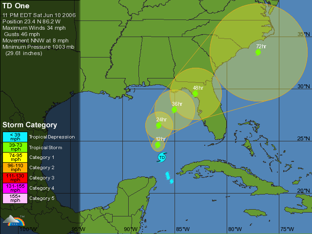
Tropical Depression One Over The Eastern Gulf of Mexico

...Tropical depression over the eastern Gulf of Mexico...forecast to become a tropical storm...

interests in the eastern Gulf of Mexico should monitor the progress of this system. The depression is moving toward the north-northwest near 9 mph andthis track should continue through Sunday.Maximum sustained winds are near 35 mph...55 km/hr...with higher gusts mainly in squalls to the north and east of the center. The depression could become a tropical storm on Sunday.

Estimated minimum central pressure is 1003 mb...29.62 inches. At this time...the main hazard associated with the depression is heavy rainfall. The depression is expected to produce total
rainfall accumulations of 10 to 20 inches over the western half of Cuba...with isolated totals of 30 inches over the higher terrain. This could cause devastating flash floods and mud slides. Rainfall
totals of 3 to 5 inches are possible over the northeastern portion of the Yucatan Peninsula. There is also the potential for heavy rainfall of 4 to 8 inches possible over the Florida Keys and western Florida through Monday.

Wednesday, June 07, 2006

First Storm Of The Season?

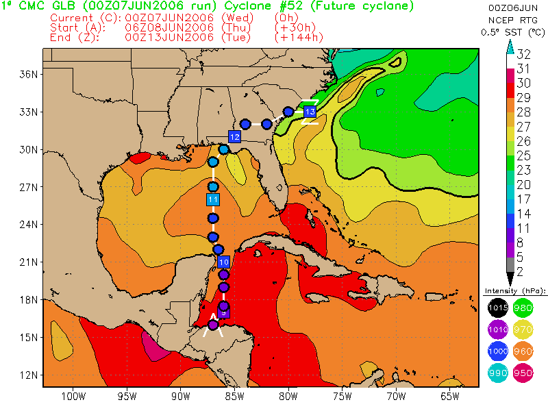
The 00Z Canadian develops a potent TC near Belize then shoots it north into the Florida Panhandle.

Also the 00Z Nogaps develops a closed low in the same area then moves it into the Western GOM, then dissipates it.

But other models show no such thing, and the National Hurricane Center isn't saying anything so far, telling us only: "TROPICAL STORM FORMATION IS NOT EXPECTED THROUGH THURSDAY."

We will just have to wait and see.

When Is Hurricane Season In The Atlantic?


Hurricane Season in the Atlantic runs from June 1 to November 30. As you can see from the graph above, the activity ramps up in August and peaks once in early September then again in October. Persons travelling to areas near the Atlantic basin should exercise caution during Hurricane Season.

Tuesday, June 06, 2006

Fewer Than One in Five U.S. Gulf and East Coast Residents Feel 'Very Prepared' for Hurricane or Flood According to Survey

Following the most devastating hurricane season in U.S. history, only 18 percent of adult residents living in the U.S. Gulf and Southern East Coast states, from Texas to Delaware(1), say their family is "very prepared" for a natural disaster, such as a hurricane or flood, according to a recent survey commissioned by The Home Depot and the American Red Cross as part of a three-year partnership to increase preparedness. The survey was conducted by Harris Interactive.

Additional Key Survey Findings
- Only 37 percent of Gulf and Southern East Coast residents are "concerned" or "very concerned" that they and their families will be in danger due to a hurricane or flood during hurricane season (June 1-November 30).

- Nearly one in three (31 percent) say they do not know how to protect their family and home from a hurricane.

- More than half (55 percent) do not have a disaster supplies kit, and more than two in five (47 percent) do not have an evacuation plan in case of a natural disaster, such as a hurricane or flood.

- Only two in five (40 percent) are more concerned about the possibility of being impacted by a hurricane or flood now than they were three years ago.

"During the past two years, the hurricanes that have hit the Gulf region of the United States have had a devastating impact on millions of people and hundreds of local communities," said Paul Raines, president, Southern Division, The Home Depot. "These recent survey findings show us that continued education about hurricane preparedness is necessary. As part of our partnership with the Red Cross, we have developed a series of hurricane- readiness clinics in order to help our customers and neighbors better protect their families and homes."

Every Saturday from May 27-Sept. 30, 2006, The Home Depot will offer the in-store hurricane readiness clinics covering the following: How to Prepare for a Hurricane, ABCs of Hurricane Preparation, How to Protect Your Property From Wind, and How to Build Our Family Disaster Supplies Kit. The clinics will be held from 11 a.m.-12 p.m. (local time) and offered on a four-week rotation schedule.

Thursday, June 01, 2006

Get set for another hurricane season

By Robert P. King
Palm Beach Post Staff Writer

How many times do you need to hear this?

Get set for yet another harried hurricane season, Colorado State University researchers said Wednesday, because the one that begins today should be a doozy.

Prospects appear especially grim for Florida and the East Coast of the U.S., which stand a 69 percent chance of experiencing a major hurricane of at least Category 3 strength -- more than double the odds of an average year, they said.

That's one category stronger than Hurricane Wilma was Oct. 24, when it tossed railroad cars off their tracks in the Glades and left nearly 6 million people across South Florida without power.

The Gulf Coast, which took the brunt of Katrina, Rita and Dennis in 2005, has a 38 percent chance of another major hurricane strike this year, the scientists said. That's slightly higher than average.

Nobody can say for sure where the storms will strike, researchers Philip Klotzbach and William Gray cautioned. But key symptoms of the global climate point to a season in which hurricanes streaming west across the Atlantic will have a greater chance of striking land rather than curving harmlessly out to sea, they said.

Meanwhile, hurricane-friendly winds and warmer-than-average ocean temperatures, though not as scalding as last year, point to a bumper crop of hurricanes forming.

Wednesday's forecast comes a week after federal meteorologists issued a similar prediction for a busy season, calling on coastal residents to prepare for the worst. Public and private researchers on both sides of the Atlantic have issued similar prognostications in recent months.

In fact, the Colorado State scientists, who adjust their predictions every few months, haven't wavered since December in their forecasts for the number of tropical storms, hurricanes and major hurricanes.

They're calling for a total of 17 named storms, which would carry us all the way to Rafael.

That sounds a lot calmer than last year's record 28-storm season, which ventured into the Greek alphabet and ended with Zeta. Then again, 17 storms would be almost 80 percent more than the yearly average seen during the latter half of the 20th century.

Klotzbach and Gray's forecast includes nine hurricanes, compared with an average of 5.9, and five major hurricanes, compared with an average of 2.3.

"The conditions that we thought were likely to be present during the hurricane season still look like what we saw in the December hurricane forecast," Klotzbach said. "The Atlantic conditions haven't changed a whole lot."

Gray has been a pioneer in the tricky task of forecasting storm totals months in advance -- some years more successfully than others. (This time last year, he was predicting a mere 15 storms.)

Two years ago, he and Klotzbach started predicting the odds of storms hitting particular stretches of the coast, right down to the county.

Wednesday's forecast adds a new factor: the global atmospheric "steering currents" that can move storms toward or away from land.

Some of those relate to the Bermuda High, a zone of high pressure that squats on or near the southeastern U.S. coast in the summer and fall. Depending on where it sits, the high and its clockwise-swirling winds can steer hurricanes either onto land or into the North Atlantic.

In 2004, the high was so far west that it gave approaching storms no place to go but into Florida, contributing to our six-week spree of Charley, Frances, Ivan and Jeanne. Atmospheric patterns over the Northeast and Canada show the high may end up in a similar position this year, Klotzbach said.

Some meteorologists have tried to tie the Bermuda High's behavior to phenomena such as May rainfall in South Florida.

Others, such as National Hurricane Center Director Max Mayfield, have avoided making such prophecies.

"People are asking if the steering currents will stay the same, and the bottom line is nobody can tell you that," Mayfield said in April at the National Hurricane Conference in Orlando.

Klotzbach acknowledged that nothing about such forecasts is certain.

"It tells you something," he said. "You can't say what particular time or what particular town."

Among other details, Klotzbach and Gray said the portion of Florida's coast stretching from the Martin-St. Lucie county line to south of Naples has a 6 percent chance of feeling a major hurricane this year. The region also has a 1-in-4 chance of experiencing a hurricane of any strength, and a 76 percent chance of withstanding at least a tropical storm, they said.

All those numbers are more than twice the average.
Wednesday, May 31, 2006

Hurricane forecaster still expects active season

Hang on to your plywood and bottled water: One of the nation's leading hurricane forecasters is predicting yet another harried season - and an especially scary one for the U.S. East Coast, including Florida.

"The odds of a major hurricane making landfall along the East Coast are more than twice the climatological average value this year," wrote a team of hurricane researchers led by William Gray of Colorado State University. Those odds are increased by factors such as the recent weak La Nina pattern of cold water in the eastern Pacific.

Gray and his associate, Phil Klotzbach, also predicted that the season will produce sharply more storms than average, for yet another year, though not as outlandish as last year's record total of 28 storms.

Their forecast calls for a total of 17 named storms this year - far above the average of 9.6. They also predicted nine hurricanes, versus an average of 5.9, and five major hurricanes of Category 3 or higher strength (the average count for those is 2.3). Last year produced 15 hurricanes, an all-time record, including a near-record seven major storms.

The predicted storm totals are the same that Gray and Klotzbach have been reporting since December.

But their predicted odds of hurricane landfalls are especially disquieting.

Florida and the U.S. East Coast have a 94 percent chance of being hit by any storm this year - and a 69 percent chance of suffering a blow from a major hurricane, Gray and Klotzbach wrote. In an average year, that region would have an 81 percent chance of being hit by any storm, and ony a 31 percent chance of a major hurricane strike.

"For the Gulf Coast, landfall probabilities are above the climatological average; however, they are not as high as those for the East Coast," Gray and Klotzbach wrote.

On the Web:
Gray's official forecast site

Tuesday, May 30, 2006

Be Hurricane Aware

If you are HURRICANE AWARE you will be able to answer these three questions:

1. What are the Hurricane Hazards?
Storm Surge, Marine Hazards, Tornadoes, High Winds, and Inland Flooding

2. What does it mean to you?
Do you live in a Surge Zone? On a Barrier Island? In an area prone to flooding? In a strong sturdy home?

3. What actions should you take to be prepared?
Family Disaster Plan, Disaster Supply Kit, Secure your home, Have a place to go, and Stay Aware

TAKING ACTION is as easy as 1-2-3:

1 - BEFORE

Before Hurricane Season Starts YOU SHOULD:

• Assemble your
Disaster Supply Kit.
These items are often scattered around your home and simply need to be brought together into one location.
Write out your Family Disaster Plan.
Discuss the possible hazards with your family. Determine if you are in an evacuation area. Identify an out-of-town family contact.

2 - WATCH

When a Hurricane Watch is issued YOU SHOULD:

• Check your Disaster Supply Kit.
Make sure nothing is missing. Determine if there is anything you need to supplement your kit. Replenish your water.
Activate your Family Disaster Plan.
Protective measures should be initiated, especially those actions that require extra time (for example, securing a boat or leaving a barrier island).

3 - WARNING

When a Hurricane Warning is issued YOU SHOULD:

• Ready your Disaster Supply Kit for use.
If you need to evacuate, you should bring your Supply Kit with you.
• Use your Family Disaster Plan.
Your family should be in the process of completing protective actions and deciding the safest location to be during the storm.

Friday, May 26, 2006

Be Prepared

"Preventing the loss of life and minimizing the damage to property from hurricanes are responsibilities that are shared by all."

Throughout this Web site, information has been provided regarding actions that you can take based on specific hurricane hazards. The most important thing that you can do is to be informed and prepared. Disaster prevention includes both being prepared as well as reducing damages (mitigation).

Disaster Prevention should include:
Developing a Family Plan
Creating a Disaster Supply Kit
Having a Place to Go
Securing your Home
Having a Pet Plan

One of the most important decisions you will have to make is "Should I Evacuate?"

If you are asked to evacuate, you should do so without delay. But unless you live in a coastal or low-lying area, an area that floods frequently, or in manufactured housing, it is unlikely that emergency managers will ask you to evacuate. That means that it is important for you and your family to HAVE A PLAN that makes you as safe as possible in your home.

Disaster prevention includes modifying your home to strengthen it against storms so that you can be as safe as possible. It also includes having the supplies on hand to weather the storm. The suggestions provided here are only guides. You should use common sense in your disaster prevention.

- DEVELOP A FAMILY PLAN - Your family's plan should be based on your vulnerability to the Hurricane Hazards. You should keep a written plan and share your plan with other friends or family.
- CREATE A DISASTER SUPPLY KIT - There are certain items you need to have regardless of where you ride out a hurricane. The disaster supply kit is a useful tool when you evacuate as well as making you as safe as possible in your home.
- SECURE YOUR HOME - There are things that you can do to make your home more secure and able to withstand stronger storms.
- ONLINE VULNERABILITY INFO - There are web sites that can give you information about your communities vulnerability to specific hazards. These include hurricanes as well as other weather related hazards.

Thursday, May 25, 2006

Hurricane Perparedness - Forcast Process

Part of the mission of the National Weather Service (NWS) Tropical Prediction Center (TPC) is to save lives and protect property by issuing watches, warnings, forecasts, and analyses of hazardous weather conditions in the tropics. This section provides information about the roles of those responsible for providing hurricane information to emergency managers and decision makers.

The TPC is comprised of the National Hurricane Center (NHC), the Tropical Analysis and Forecast Branch (TAFB), and the Technical Support Branch (TSB). During hurricane season, the latter two provide support to the NHC.

The local NWS Weather Forecast Offices (WFOs) in hurricane-prone areas are also important participants in the forecast process.

The NHC and your local WFO have various roles in the forecast process that are closely coordinated. Their activities are summarized below.

OBSERVATION
Observations including satellites, buoys, reconnaissance aircraft, and radar are the basis for all forecast and warning products issued by the NHC. Quality, quantity, and timeliness of remote sensing observations are critical for accurate and timely forecasts and warnings. Learn More

ANALYSIS
The various observations are checked for quality, analyzed, and put into a suite of computer models. Learn More

MODEL GUIDANCE AND INTERPRETATION
The computer models take in the observations and perform millions of calculations to generate predictions of hurricane behavior and the general conditions of the atmosphere in which the hurricane is embedded. The model results are packaged as guidance for the appropriate national centers and local offices and for evaluation and use in the NWS's forecast and warning process. Learn More

COORDINATION WITHIN THE NEWS
Forecasts and warnings are coordinated between the national centers and local forecast offices to provide consistency, which is critical during severe weather episodes. Learn More

PRODUCT GENERATION
Once the coordination and collaboration process reaches group consensus, the issuing offices generate forecast and warning products for release to the public. Learn More

Coordination with Customers
The NHC and the local NWS forecast office work with your community leaders to determine whether the forecast and warning products issued were useful and how they can provide you even better service in the future. Learn More

RELATED INFORMATION
HURRICANE FORECAST PRODUCTS
GRAPHICAL FORECAST PRODUCTS
COORDINATION PROCESS
OBSERVATIONS & DATA
FORECAST ERRORS
WATCHES & WARNINGS

Wednesday, May 24, 2006

New Orleans seen top target for '06 hurricanes

ORLANDO, Florida (Reuters) - New Orleans, still down and out from last year's assault by Hurricane Katrina, is the U.S. city most likely to be struck by hurricane force winds during the 2006 storm season, a researcher said on Wednesday.

The forecast gives New Orleans a nearly 30 percent chance of being hit by a hurricane and a one in 10 chance the storm will be a Category 3 or stronger, meaning sustained winds of at least 111 miles per hour (178 km per hour), said Chuck Watson of Kinetic Analysis Corp., Savannah, Georgia a risk assessment firm.

"Given the state of the infrastructure down there and the levees, gosh, that's just not good news. But that's what the climate signals look like," Watson said.

Watson, who has partnered with University of Central Florida statistics professor Mark Johnson, also predicted that oil production in the Gulf of Mexico will be disrupted for a minimum of a week at a cost of 7-8 million barrels of oil.

Up to 25 percent of U.S. oil production in the Gulf was shut down last year and 20 percent is still out.

Watson gave a one in 10 chance that oil rigs will sustain enough damage to reduce production by 278 million barrels this year, further escalating prices for gasoline.

The forecasters, who have worked with the oil and gas industry and with state insurance regulators, base their forecast in part on the paths of storms over the past 155 years and expected global climate conditions this year.

Watson and Johnson said a weak La Nina weather condition and warmer-than-normal Gulf of Mexico water temperatures were contributing factors. U.S. government weather experts say the La Nina phenomenon in place earlier this year has dissipated and should not be a factor during the hurricane season.

On Tuesday, the U.S. National Oceanic and Atmospheric Administration said the 2006 hurricane season was expected to produce 13 to 16 named storms, including four to six "major" hurricanes of Category 3 strength or higher. No leading forecasters came close to predicting what happened in 2005, when 28 tropical storms spawned a record 15 hurricanes.

The 2006 forecast for News Orleans was worse than Watson's prediction for the city last year, he said. But for now, he considers the 2005 season an aberration rather than a trend or a definitive sign of effects from global warming.

"If it happens again this year or next year, then we're in a different climate world than we were in the last 100 years or so," Watson said.

Of 28 coastal cities evaluated under the forecast model, New Orleans ranked top with a 29.3 percent chance of experiencing hurricane-force winds in the storm season that begins officially on June 1.

Other top candidates include Mobile, Alabama, with a 22 percent chance of being buffeted by hurricane-force winds, and the Florida cities of Key West and Pensacola, which both have a 20 percent chance.

West Palm Beach, Florida, which suffered severe damage during last year's Hurricane Wilma, came in just after Key West and Pensacola with a 19 percent chance of being struck yet again by hurricane-force winds.

Watson and Johnson have published a number of research papers on storm and wind damage modeling.

Hurricane Perparedness - Inland Flooding

"In the 1970s, '80s, and '90s, inland flooding was responsible for more than half of the deaths associated with tropical cyclones in the United States." - Ed RappaportNational Hurricane Center

Consider the following:
When it comes to hurricanes, wind speeds do not tell the whole story. Hurricanes produce storm surges, tornadoes, and often the most deadly of all - inland flooding.

While storm surge is always a potential threat, more people have died from inland flooding from 1970 up to 2000. Intense rainfall is not directly related to the wind speed of tropical cyclones. In fact, some of the greatest rainfall amounts occur from weaker storms that drift slowly or stall over an area.

Inland flooding can be a major threat to communities hundreds of miles from the coast as intense rain falls from these huge tropical air masses.

Tropical Storm Allison (2001) produced extremely heavy rainfall and catastrophic floods in the Houston, Texas area. Allison then acquired subtropical characteristics and continued to produce heavy rainfall and flooding near its track from Louisiana eastward to North Carolina, and then northward along the U.S. east coast to Massachusetts. Forty-one deaths were directly related to the heavy rain, flooding, tornadoes, and high surf. Damage estimates reported by the Federal Emergency Management Agency (FEMA) were near $5 billion, with approximately $4.8 billion in the Houston metropolitan area alone.

Hurricane Floyd (1999) brought intense rains and record flooding to the Eastern U.S. Of the 56 people who perished, 50 drowned due to inland flooding.

Tropical Storm Claudette (1979) brought 45 inches of rain to an area near Alvin, Texas, contributing to more than $600 million in damages.

Hurricane Agnes (1972) produced floods in the Northeast United States which contributed to 122 deaths and $6.4 billion in damages. Long after the winds from Hurricane Diane (1955) subsided, the storm brought inland flooding to Pennsylvania, New York, and New England contributing to nearly 200 deaths and $4.2 billion in damages.

In a study from 1970 to 1999, freshwater flooding accounted for more than half (59%) of U.S. tropical cyclone deaths. These floods are why 63% of U.S. tropical cyclone deaths during that period occurred in inland counties.

At least 23% of U.S. tropical cyclone deaths occur to people who drown in, or attempting to abandon, their cars.

78% of children killed by tropical cyclones drowned in freshwater floods.

So, the next time you hear hurricane -- think inland flooding!

What can you do?
- When you hear hurricane, think inland flooding.
- Determine whether you live in a potential flood zone.
- If advised to evacuate, do so immediately.
- Keep abreast of road conditions through the news media.
- Move to a safe area before access is cut off by flood water.
- Do not attempt to cross flowing water. As little as six inches of water may cause you to lose control of your vehicle.
- Develop a flood emergency action plan.
- Have flood insurance. Flood damage is not usually covered by homeowners insurance. Do not make assumptions. Check your policy.

Tuesday, May 23, 2006

Home Depot To Match Hurricane Sales Tax Discounts

Sales Tax Holiday Runs May 21 - June 1
The Tax Break Expected To Save Consumers $41 Million


(CBS4 News) MIAMI As another hurricane season lurks just around the corner, retailer The Home Depot, makes a move that it hopes will lure shoppers into their home improvement stores for hurricane supplies.

The state’s 12-day break from sales tax on hurricane related products begins Sunday and The Home Depot is now matching the discount in order to save its customers even more.

That means every state designated hurricane product will be discounted an additional 7.5%, during the 12-day tax holiday which ends June 1st, the official start of the 2006 Atlantic Hurricane season.

In addition, The Home Depots in Florida will begin offering free Hurricane preparation clinics starting May 21 through September. You can call individual stores for more details.

The so-called sales-tax holiday, approved by the state Legislature for the second year in a row, is designed to encourage residents to buy supplies that will help them get by without electricity and other basic services for up to 72 hours. The break is expected to save consumers about $41 million.

Hurricane Preparedness - High Winds

The intensity of a landfalling hurricane is expressed in terms of categories that relate wind speeds and potential damage. According to the Saffir-Simpson Hurricane Scale, a Category 1 hurricane has lighter winds compared to storms in higher categories. A Category 4 hurricane would have winds between 131 and 155 mph and, on the average, would usually be expected to cause 100 times the damage of the Category 1 storm. Depending on circumstances, less intense storms may still be strong enough to produce damage, particularly in areas that have not prepared in advance.

Tropical storm-force winds are strong enough to be dangerous to those caught in them. For this reason, emergency managers plan on having their evacuations complete and their personnel sheltered before the onset of tropical storm-force winds, not hurricane-force winds.

Hurricane-force winds can easily destroy poorly constructed buildings and mobile homes. Debris such as signs, roofing material, and small items left outside become flying missiles in hurricanes. Extensive damage to trees, towers, water and underground utility lines (from uprooted trees), and fallen poles cause considerable disruption.

High-rise buildings are also vulnerable to hurricane-force winds, particularly at the higher levels since wind speed tends to increase with height. Recent research suggests you should stay below the tenth floor, but still above any floors at risk for flooding. It is not uncommon for high-rise buildings to suffer a great deal of damage due to windows being blown out. Consequently, the areas around these buildings can be very dangerous.

The strongest winds usually occur in the right side of the eyewall of the hurricane. Wind speed usually decreases significantly within 12 hours after landfall. Nonetheless, winds can stay above hurricane strength well inland. Hurricane Hugo (1989), for example, battered Charlotte, North Carolina (which is 175 miles inland) with gusts to nearly 100 mph.

The Inland High Wind Model can be used by emergency managers to estimate how far inland strong winds extend. The inland wind estimates can only be made shortly before landfall when the windfield forecast errors are relatively small. This information is most useful in the decision-making process to decide which people might be most vulnerable to high winds at inland locations.

QUESTIONS TO ASK YOUR COMMUNITY LEADERS
Does your community building code set standards that will help buildings withstand winds in a major hurricane?

Do your shelter facilities include long-span roofs or unreinforced masonry walls (such as gymnasiums) that are vulnerable in high winds?

Hurricane Preparedness - Storm Surge

"The greatest potential for loss of life related to a hurricane is from the storm surge." - Brian Jarvinen, National Hurricane Center

Storm surge is simply water that is pushed toward the shore by the force of the winds swirling around the storm. This advancing surge combines with the normal tides to create the hurricane storm tide, which can increase the mean water level 15 feet or more. In addition, wind driven waves are superimposed on the storm tide. This rise in water level can cause severe flooding in coastal areas, particularly when the storm tide coincides with the normal high tides. Because much of the United States' densely populated Atlantic and Gulf Coast coastlines lie less than 10 feet above mean sea level, the danger from storm tides is tremendous.

The level of surge in a particular area is also determined by the slope of the continental shelf. A shallow slope off the coast (right, top picture) will allow a greater surge to inundate coastal communities. Communities with a steeper continental shelf (right, bottom picture) will not see as much surge inundation, although large breaking waves can still present major problems. Storm tides, waves, and currents in confined harbors severely damage ships, marinas, and pleasure boats.

One tool used to evaluate the threat from storm surge is the SLOSH model. Emergency managers use this data from SLOSH to determine which areas must be evacuated for storm surge. The links below provide some altered photos that show how the intensity of the storm (as given by the Saffir-Simpson Hurricane Scale) affects the possibility of flooding from storm surge at two locations. Storm surge also affects rivers and inland lakes, potentially increasing the area that must be evacuated. You can see some of these effects by looking at simulated storm surge pictures for Brunswick, GA, New Orleans, LA, Brooklyn, NY, Wrightsville Beach, NC and Manteo, NC.

In general, the more intense the storm, and the closer a community is to the right-front quadrant, the larger the area that must be evacuated. The problem is always the uncertainty about how intense the storm will be when it finally makes landfall. Emergency managers and local officials balance that uncertainty with the human and economic risks to their community. This is why a rule of thumb for emergency managers is to plan for a storm one category higher than what is forecast. This is a reasonable precaution to help minimize the loss of life from hurricanes.

Wave and current action associated with the tide also causes extensive damage. Water weighs approximately 1,700 pounds per cubic yard; extended pounding by frequent waves can demolish any structure not specifically designed to withstand such forces.

The currents created by the tide combine with the action of the waves to severely erode beaches and coastal highways. Many buildings withstand hurricane force winds until their foundations, undermined by erosion, are weakened and fail.In estuaries and bayous, intrusions of salt water endanger the public health and send animals, such as snakes, to flee from flooded areas and take refuge in urban areas.

Monday, May 22, 2006

NOAA PREDICTS VERY ACTIVE 2006 NORTH ATLANTIC HURRICANE SEASON

May 22, 2006 — NOAA today announced to America and its neighbors throughout the north Atlantic region that a very active hurricane season is looming, and encouraged individuals to make preparations to better protect their lives and livelihoods. May 21-27 is National Hurricane Preparedness Week.

During a news conference at the NOAA National Hurricane Center, Deputy Secretary of Commerce David A. Sampson noted, "Preparation is the key message that President Bush wants to convey during National Hurricane Preparedness Week. The impact from these storms extends well beyond coastal areas so it is vital that residents in hurricane prone areas get ready in advance of the hurricane season."

"For the 2006 north Atlantic hurricane season, NOAA is predicting 13 to 16 named storms, with eight to 10 becoming hurricanes, of which four to six could become 'major' hurricanes of Category 3 strength or higher," added retired Navy Vice Adm. Conrad C. Lautenbacher, Ph.D., undersecretary of commerce for oceans and atmosphere and NOAA administrator.

On average, the north Atlantic hurricane season produces 11 named storms, with six becoming hurricanes, including two major hurricanes. In 2005, the Atlantic hurricane season contained a record 28 storms, including 15 hurricanes. Seven of these hurricanes were considered "major," of which a record four hit the United States. "Although NOAA is not forecasting a repeat of last year's season, the potential for hurricanes striking the U.S. is high," added Lautenbacher.

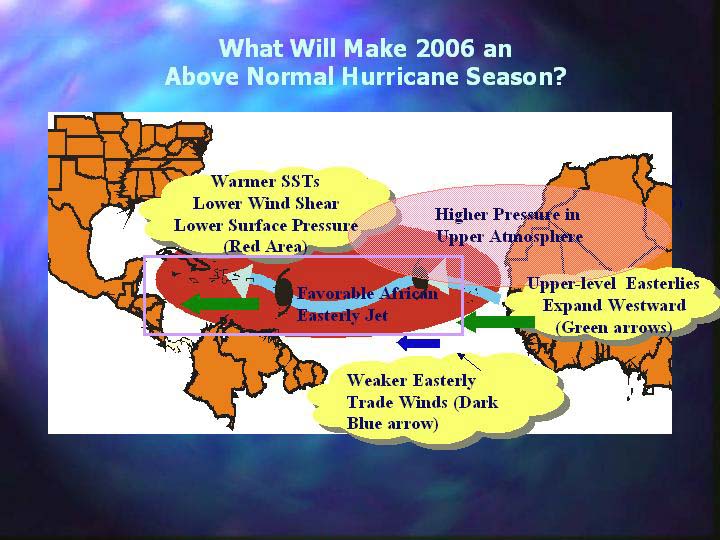
Warmer ocean water combined with lower wind shear, weaker easterly trade winds, and a more favorable wind pattern in the mid-levels of the atmosphere are the factors that collectively will favor the development of storms in greater numbers and to greater intensity. Warm water is the energy source for storms while favorable wind patterns limit the wind shear that can tear apart a storm's building cloud structure.

This confluence of conditions in the ocean and atmosphere is strongly related to a climate pattern known as the multi-decadal signal, which has been in place since 1995. Since then, nine of the last 11 hurricane seasons have been above normal, with only two below-normal seasons during the El Niño years of 1997 and 2002.

With neutral El Niño/Southern Oscillation (ENSO) conditions expected across the equatorial Pacific during the next three to six months, the NOAA Climate Prediction Center scientists say that neither El Niño nor La Niña likely will be a factor in this year's hurricane season.

"Whether we face an active hurricane season, like this year, or a below-normal season, the crucial message for every person is the same: prepare, prepare, prepare," said Max Mayfield, director of the NOAA National Hurricane Center. "One hurricane hitting where you live is enough to make it a bad season."

The north Atlantic hurricane season runs from June 1 through November 30. NOAA will issue a mid-season update in early August just prior to the normal August through October peak in activity.

The north Atlantic hurricane seasonal outlook is a product of NOAA's Climate Prediction Center, National Hurricane Center and Hurricane Research Division. The NOAA National Hurricane Center has hurricane forecasting responsibilities for the north Atlantic as well as the east Pacific regions.

NOAA, an agency of the U.S. Department of Commerce, is dedicated to enhancing economic security and national safety through the prediction and research of weather and climate-related events and providing environmental stewardship of the nation's coastal and marine resources.

Through the emerging Global Earth Observation System of Systems (GEOSS), NOAA is working with its federal partners, 61 countries and the European Commission to develop a global network that is as integrated as the planet it observes, predicts and protects.

Names for Atlantic Basin Tropical Cyclones

2006 Tropical Cyclones Names:
Alberto, Beryl, Chris, Debby, Ernesto, Florence, Gordon, Helene, Isaac, Joyce, Kirk, Leslie, Michael, Nadine, Oscar, Patty, Rafael, Sandy, Tony, Valerie, William

Hurricane Basics

The ingredients for a hurricane include a pre-existing weather disturbance, warm tropical oceans, moisture, and relatively light winds aloft. If the right conditions persist long enough, they can combine to produce the violent winds, incredible waves, torrential rains, and floods we associate with this phenomenon.

Each year, an average of ten tropical storms develop over the Atlantic Ocean, Caribbean Sea, and Gulf of Mexico. Many of these remain over the ocean and never impact the U.S. coastline. Six of these storms become hurricanes each year. In an average 3-year period, roughly five hurricanes strike the US coastline, killing approximately 50 to 100 people anywhere from Texas to Maine. Of these, two are typically "major" or "intense" hurricanes (a category 3 or higher storm on the Saffir-Simpson Hurricane Scale).

What is a Hurricane?
A hurricane is a type of tropical cyclone, which is a generic term for a low pressure system that generally forms in the tropics. The cyclone is accompanied by thunderstorms and, in the Northern Hemisphere, a counterclockwise circulation of winds near the earth's surface. Tropical cyclones are classified as follows:

Tropical Depression
An organized system of clouds and thunderstorms with a defined surface circulation and maximum sustained winds* of 38 mph (33 kt**) or less

Tropical Storm
An organized system of strong thunderstorms with a defined surface circulation and maximum sustained winds of 39-73 mph (34-63 kt)

Hurricane
An intense tropical weather system of strong thunderstorms with a well-defined surface circulation and maximum sustained winds of 74 mph (64 kt) or higher

Hurricanes are categorized according to the strength of their winds using the Saffir-Simpson Hurricane Scale. A Category 1 storm has the lowest wind speeds, while a Category 5 hurricane has the strongest. These are relative terms, because lower category storms can sometimes inflict greater damage than higher category storms, depending on where they strike and the particular hazards they bring. In fact, tropical storms can also produce significant damage and loss of life, mainly due to flooding.

Hurricane Names
When the the winds from these storms reach 39 mph (34 kts), the cyclones are given names. Years ago, an international committee developed names for Atlantic cyclones (The History of Naming Hurricanes). In 1979 a six year rotating list of Atlantic storm names was adopted — alternating between male and female hurricane names. Storm names are used to facilitate geographic referencing, for warning services, for legal issues, and to reduce confusion when two or more tropical cyclones occur at the same time. Through a vote of the World Meteorological Organization Region IV Subcommittee, Atlantic cyclone names are retired usually when hurricanes result in substantial damage or death or for other special circumstances. The names assigned for the period between 2002 and 2007 are shown below.