A robust tropical wave continues to produce squally conditions across the Lesser Antilles Thursday. The wave, along 63 west and south of 20 north, is tracking to the west at 15 knots and will move into the western Caribbean later this weekend. It will bring gusty winds and numerous showers and thunderstorms to Puerto Rico today and then Hispaniola on Friday. An upper-level trough is causing a southwest shear across the eastern Caribbean and over the top of this wave so any development will be slow for the time being. The upper-level trough will back to the west over the next couple of days and so will the shear, but if the wave continues to track under the shear, then development will continue to be slow. Tropical moisture from this wave should increase the chance of showers and thunderstorms across central and South Florida later in the weekend.
Another tropical wave along 96 west and south of 20 north is moving west at 10-15 knots, but convection associated with it has greatly diminished. Moisture from this wave will bring much-needed showers and thunderstorms to South Texas over the weekend.
Farther east, another tropical wave is located along 47 west and south of 10 north. It is moving west at 10-15 knots and shows little sign of organization.
Thursday, June 29, 2006
Wednesday, June 28, 2006
Tropical Downpours Continue in East
 Low pressure continues to surge northward into the Northeast Wednesday morning, producing tropical downpours from eastern New York into New England. Gales are possible just to the east of the center as well as it moves from western Connecticut toward northern New England. But, the main story will be the flooding rain that will continue over areas that have already been hard-hit over the last couple of months.
 Elsewhere in the tropics, a tropical wave is moving through Central America and the Yucatan Peninsula, and is spreading thunderstorms over much of Central America, and the northern end of the wave will cross the Bay of Campeche. There are no signs of organization with the wave at this point, but it is possible that some of this wave's moisture will be pulled into South Texas by Friday, which would result in welcome rainfall in this drought-stricken region. The weather is generally quiet over the rest of the Caribbean at this time. The only other tropical wave to watch is approaching the Lesser Antilles and will cause thunderstorms there Wednesday. This feature also shows no signs of imminent organization.
An upper-level disturbance about halfway between Puerto Rico and Bermuda will continue to move toward the northwest over the next 24 hours. This may begin to affect Bermuda with showers late Wednesday, then pass closer to the island Wednesday night or Thursday.

Monday, June 26, 2006
New threat area east of the Windward Islands
 A new area worth watching has cropped up near 7N 47W, about 1050 miles east-southeast of the southern Windward Islands. There is some heavy thunderstorm activity here and a 1012 mb low pressure area has developed. This low is moving west towards an area of higher wind shear, and is not expected to develop. Wind shear over most of the Atlantic is expected to remain seasonably high over the next week, making it difficult for tropical storm formation.
 Preliminary model tracks for the low east of the Windward Islands.
Intense storms blamed on heat
Storms blamed on global warming
Global warming, not natural fluctuations in ocean temperature, was the main cause of the ocean heat that energized last year's killer hurricanes, scientists at a federally funded climate laboratory said Thursday.
Global warming, not natural fluctuations in ocean temperature, was the main cause of the ocean heat that energized last year's killer hurricanes, scientists at a federally funded climate laboratory said Thursday.
As a result, continued increases in the Earth's temperature likely will lead to more "enhanced hurricane activity" in future years, said climate analysts Kevin Trenberth and Dennis Shea of the National Center for Atmospheric Research in Boulder, Colo.
Hurricanes draw their energy from the ocean, and scientists on both sides of the debate agree that rising Atlantic Ocean temperatures have driven the past decade's increasingly violent hurricanes.
Last year, for example, the temperature in the tropical Atlantic, where many hurricanes originate, was about 1.6 degrees Fahrenheit above the average for the first 70 years of the 20th century.
The year produced the most named storms on record (28), forcing the National Hurricane Center to go into the Greek alphabet for names. It also brought the most intense Atlantic storm on record (Wilma), the most intense storm to hit the Gulf of Mexico (Rita) and the most destructive storm on record (Katrina).
Some experts, including National Hurricane Center Director Max Mayfield and Colorado State University forecaster William Gray, have discounted the effects of global warming.They contend that higher ocean temperatures are a result of a long-term cycle known as the Atlantic multidecadal oscillation.
A rise and fall in the ocean's temperature has been documented as far back as the late 1800s.
But in a study described in the Geophysical Research Letters, Trenberth and Shea said the current rise is only partly caused by the oscillation.
They deducted a global temperature increase that scientists have monitored since the 1970s from changes observed in the Atlantic during the same period, and concluded that very little of the increased Atlantic temperature was caused by the ocean temperature cycle.
They attributed 0.8 degrees of the extra temperature to global warming and about 0.2 degrees to the oscillation. The remainder is due to the after-effects of the 2004-05 El Niño warm-water current in the Pacific Ocean and year-to-year variability, they said.
"I don't see how the hell they can say that," said Gray, 76, professor emeritus of atmospheric sciences at Colorado State. "We're just in one of these warming trends due to the ocean circulation and there's nothing we can do about it."
But Georgia Tech scientist Peter Webster, who this year reported that rising ocean temperatures worldwide are directly linked to a 35-year trend of increased hurricane strength, said the calculations by Trenberth and Shea were "fundamentally sound."
"The Atlantic oscillation is there, but it's being out-ridden by global warming," he said.
In a separate report released Thursday, a committee of the National Academy of Sciences said that "proxy" climate records, such as the width of tree rings and the chemical makeup of ice from deep beneath the Greenland snowpack, indicate with "high confidence" that the Earth is warmer now than it has been in the past 400 years.
The academy's study was made at the request of Congress. Industry representatives and global-warming skeptics attacked a earlier proxy temperature study that concluded that the Earth's temperature varied little for 1,000 years, then in the past 25 years began to rise sharply, at an angle reminiscent of a hockey stick.
The study has played a key role in actions by the U.N. Intergovernmental Panel on Climate Change.
The academy panel's study said the proxy evidence provides "less confidence" in climate conditions between 900 and 1600 A.D.
It said "very little confidence" could be placed in average global temperature calculations before 900.
Friday, June 23, 2006
Area Near Bahamas Bears Watching
An area of showers and thunderstorms associated with an upper level trough has been the main focus of tropical activity in the Atlantic Basin the past few days. Some shear continues to limit the organization of this system overall. In addition there appear to be two centers of circulation competing with each other. Another limiting factor is that the surface pressure remains relatively high across the region and will have to lower considerably before the system would truly become a serious threat. Computer models suggest the the shear will relax some over the next couple of days, so the system is expected to become a bit better organized. Steering winds should eventually take this system to the west or northwest and at the least rainfall in the path of this system should be enhanced. As this tropical moisture feeds into the eastern United States, it will interact with a stalled frontal boundary, resulting in heavy rainfall. It is still too early to tell where the heavy rain is most likely, but keep chacking back here for the latest details on this system.
There is a tropical waves at 57 West moving west at 15-20 kts. and another waves at 82 West moving west at 10-15 kts. There is no organization with either of these waves and so the remainder of the Atlantic Basin outside of the area near the Bahamas should be fairly tranquil the next few days.
Thursday, June 22, 2006
The Storm near the Bahamas Could Turn Tropical
 A system to the north of the Bahamas may bear watching over the next couple of days. A storm in the area will attempt to become more tropical in nature during the next couple of days. Shear continues to affect the storm's strengthening, but this should relax later Friday. At this point it will be the best chance for the storm to change to more tropical features. Either way this system is expected to move toward the coast and inland later this weekend into early next week. Tropical moisture is feeding into the overall flow of the weather pattern. This means that heavy rain is likely across much of the eastern U.S. into next week.
There is a tropical waves at 56 West moving west at 15-20 kts. and another waves at 81 West moving west at 10-15 kts.
Wednesday, June 14, 2006
Alberto downgraded as it steams across Southeast
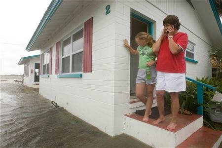 After splashing ashore in Florida without its once-feared punch, the remnants of the first named storm of the season churned through the Southeast early Wednesday, bringing much-needed rain and offering a tune-up for officials readying for the long hurricane season.
 By early Wednesday morning, Alberto had weakened from a tropical storm to a tropical depression over South Carolina and all tropical storm warnings were discontinued, forecasters at the National Hurricane Center said. The storm was expected to lose all tropical characteristics later in the day, though it was possible the storm could strengthen again.
After last year's 28 named storms and record 15 hurricanes, Tropical Storm Alberto caused a brief scare and prompted a call for more than 20,000 people to evacuate Florida's Gulf Coast. But no serious injuries or deaths were reported.
Tuesday, June 13, 2006
Alberto leaves thousands powerless on Gulf Coast
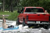 Tropical Storm Alberto pelted Florida's Gulf Coast with rain before it made landfall Tuesday, but early reports indicated its winds, storm surge and other effects were not as serious as initially feared.
 The storm's center came ashore around 12:30 p.m. near Adams Beach, about 50 miles southeast of Tallahassee, the National Hurricane Center said. Alberto's top sustained winds were 40 mph, down from 65 mph earlier in the day. The minimum wind speed for a hurricane is 74 mph.
About 21,000 homes and businesses were without power statewide and some streets flooded in coastal towns. Water levels approached several houses and businesses near Crystal River to the south. Residents gathered in calf-deep water on streets and parking lots and dropped sandbags in preparation for the afternoon high tide.
Little damage reported from Alberto in Fla
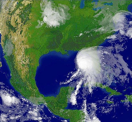 CEDAR KEY, Fla. - The first tropical storm of the 2006 Atlantic hurricane season pelted Florida's gulf coast with rain Tuesday, but forecasters said Alberto wouldn't reach hurricane strength as earlier feared.
 The National Hurricane Center downgraded its hurricane warning on parts of Florida's Gulf Coast to a tropical storm warning midmorning.
Alberto's top sustained winds had dropped to 50 mph, well below the 74 mph threshold for a hurricane.
Alberto weakens as it nears landfall
 Thousands ordered to flee ahead of tropical storm
 A slightly weakened Tropical Storm Alberto approached the northern Gulf Coast of Florida early Tuesday, with maximum sustained winds at 65 mph, the National Hurricane Center reported.
A hurricane warning was in place from the Tampa Bay area to near Tallahassee.
Forecasters urged people to quickly make "preparations to protect life and property" as the eye of Alberto neared shore.
The NHC currently predicts the storm could make landfall about midday.
Florida Gov. Jeb Bush issued a mandatory evacuation order for low-lying counties Dixie, Levy, Taylor, Citrus, Franklin and Wakulla, which are in the storm's path.
At 5 a.m. EDT, the center of Alberto was about 60 miles southeast of Apalachicola and about 65 miles west of Cedar Key, moving northeast at about 9 mph. Forecasters said it is likely to continue on that path through midday.
Forecasters reported coastal storm surging up to 8 to 10 feet above normal tide levels over a large portion of the warning area -- conditions that could trigger floods and mudslides -- are expected.
Rainfall could reach 10 inches Tuesday across portions of central and northern Florida and southeastern Georgia.
The hurricane warning stretches from the Ochlockonee River south to Longboat Key.
Bush advised Florida residents in the path of the storm to ensure they have enough supplies like food, medicine, water and a full tank of gas to last at least 72 hours.
Florida state officials have reported no gas shortages and said the ports are open for now, although the port of Tampa is evaluating whether to stay open.
Monday, June 12, 2006
Hurricane warning issued for Alberto
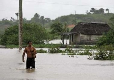 Forecasters issued a hurricane warning for parts of Florida's Gulf Coast on Monday as the first named storm of the 2006 Atlantic hurricane season quickly gained strength in the Gulf of Mexico.
The warning from Longboat Key near Sarasota to the Ochlockonee River south of Tallahassee means Tropical Storm Alberto was expected to produce hurricane conditions within the next 24 hours.
A tropical storm warning remains in effect for Longboat Key to Englewood.
At 11 a.m., Alberto's winds had increased to 70 mph, up from 50 mph just three hours earlier. The storm was centered about 190 miles south-southwest of Apalachicola and was moving north-northeast at about 7 mph, National Hurricane Center forecasters said.
Storm warning issued for Fla.'s Gulf Coast
 TAMPA, Fla. - The first named storm of the 2006 Atlantic hurricane season slightly strengthened early Monday in the Gulf of Mexico, prompting forecasters to issue tropical storm warnings for Florida's west coast.
 Tropical Storm Alberto had maximum sustained wind near 50 mph but was not likely to grow into a hurricane, the National Hurricane Center said. There were no major reports of damage.
At 5 a.m. EDT, Alberto was centered about 275 miles south-southwest of Apalachicola. It was moving north-northeast at about 8 mph and could make landfall Tuesday night, forecasters said.
"Right before landfall they expect a little stronger: 55 gusts to 65. It won't be quite hurricane strength," said Ron Goodman, a meteorologist at the National Hurricane Center. "Things can change, but right now it's not expected to be a hurricane."
Forecasters said that up to 30 inches of rain could fall over some parts of Cuba, creating a threat of flash floods and mudslides, and that 5 to 10 inches could fall over the Florida peninsula through Tuesday. Over the Florida Keys, between 3 to 5 inches of rainfall are possible.
A tropical storm warning was issued for most of Florida's west coast, from Englewood to Indian Pass, meaning tropical storm conditions were expected there within the next 24 hours. A tropical storm watch remains in effect from south of Englewood to Bonita Beach.
The tropical depression that produced Alberto formed Saturday, nine days after the official start of the hurricane season, in the northwest Caribbean, which can produce typically weak storms that follow a similar track this time of year, forecasters said.
Last year's hurricane season was the most destructive on record. Hurricane Katrina devastated Louisiana and Mississippi and was blamed for more than 1,570 deaths among Louisiana residents alone.
This year, however, meteorologists have said the Atlantic is not as warm as it was at this time in 2005, meaning potential storms would have less of the energy needed to develop into hurricanes.
Last year's first named storm was Tropical Storm Arlene, which formed June 9 and made landfall just west of Pensacola in the Florida Panhandle.
Saturday, June 10, 2006
Tropical Depression One Over The Eastern Gulf of Mexico
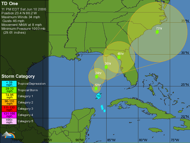 ...Tropical depression over the eastern Gulf of Mexico...forecast to become a tropical storm...
interests in the eastern Gulf of Mexico should monitor the progress of this system. The depression is moving toward the north-northwest near 9 mph andthis track should continue through Sunday.Maximum sustained winds are near 35 mph...55 km/hr...with higher gusts mainly in squalls to the north and east of the center. The depression could become a tropical storm on Sunday.
Estimated minimum central pressure is 1003 mb...29.62 inches. At this time...the main hazard associated with the depression is heavy rainfall. The depression is expected to produce total
rainfall accumulations of 10 to 20 inches over the western half of Cuba...with isolated totals of 30 inches over the higher terrain. This could cause devastating flash floods and mud slides. Rainfall
totals of 3 to 5 inches are possible over the northeastern portion of the Yucatan Peninsula. There is also the potential for heavy rainfall of 4 to 8 inches possible over the Florida Keys and western Florida through Monday.
Wednesday, June 07, 2006
First Storm Of The Season?
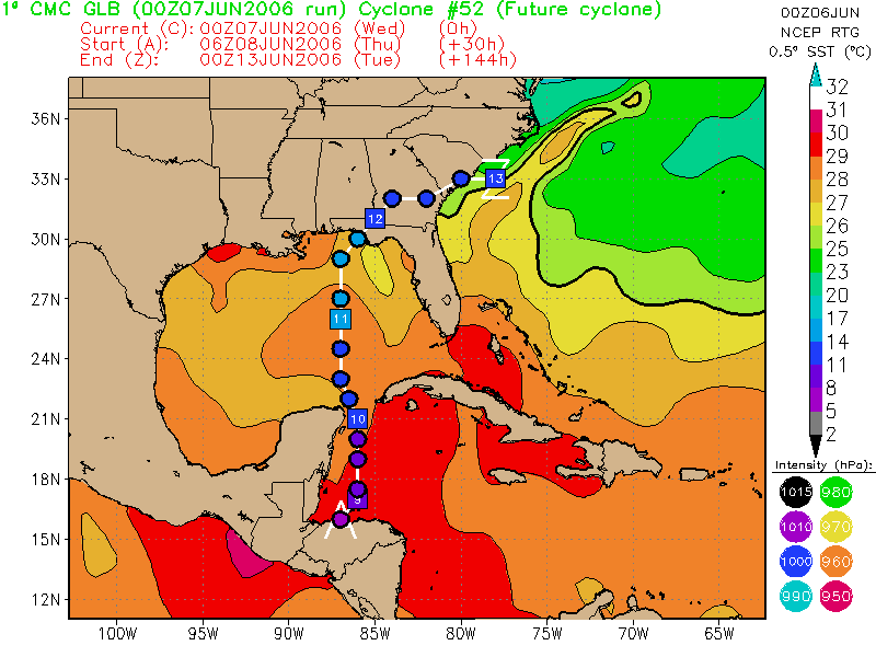 The 00Z Canadian develops a potent TC near Belize then shoots it north into the Florida Panhandle.
 Also the 00Z Nogaps develops a closed low in the same area then moves it into the Western GOM, then dissipates it.
But other models show no such thing, and the National Hurricane Center isn't saying anything so far, telling us only: "TROPICAL STORM FORMATION IS NOT EXPECTED THROUGH THURSDAY."
We will just have to wait and see.
When Is Hurricane Season In The Atlantic?

Hurricane Season in the Atlantic runs from June 1 to November 30. As you can see from the graph above, the activity ramps up in August and peaks once in early September then again in October. Persons travelling to areas near the Atlantic basin should exercise caution during Hurricane Season.
Tuesday, June 06, 2006
Fewer Than One in Five U.S. Gulf and East Coast Residents Feel 'Very Prepared' for Hurricane or Flood According to Survey
 Following the most devastating hurricane season in U.S. history, only 18 percent of adult residents living in the U.S. Gulf and Southern East Coast states, from Texas to Delaware(1), say their family is "very prepared" for a natural disaster, such as a hurricane or flood, according to a recent survey commissioned by The Home Depot and the American Red Cross as part of a three-year partnership to increase preparedness. The survey was conducted by Harris Interactive.
Additional Key Survey Findings
- Only 37 percent of Gulf and Southern East Coast residents are "concerned" or "very concerned" that they and their families will be in danger due to a hurricane or flood during hurricane season (June 1-November 30).
- Nearly one in three (31 percent) say they do not know how to protect their family and home from a hurricane.
- More than half (55 percent) do not have a disaster supplies kit, and more than two in five (47 percent) do not have an evacuation plan in case of a natural disaster, such as a hurricane or flood.
- Only two in five (40 percent) are more concerned about the possibility of being impacted by a hurricane or flood now than they were three years ago.
"During the past two years, the hurricanes that have hit the Gulf region of the United States have had a devastating impact on millions of people and hundreds of local communities," said Paul Raines, president, Southern Division, The Home Depot. "These recent survey findings show us that continued education about hurricane preparedness is necessary. As part of our partnership with the Red Cross, we have developed a series of hurricane- readiness clinics in order to help our customers and neighbors better protect their families and homes."
Every Saturday from May 27-Sept. 30, 2006, The Home Depot will offer the in-store hurricane readiness clinics covering the following: How to Prepare for a Hurricane, ABCs of Hurricane Preparation, How to Protect Your Property From Wind, and How to Build Our Family Disaster Supplies Kit. The clinics will be held from 11 a.m.-12 p.m. (local time) and offered on a four-week rotation schedule.
Thursday, June 01, 2006
Get set for another hurricane season
By Robert P. King
Palm Beach Post Staff Writer
How many times do you need to hear this?
Get set for yet another harried hurricane season, Colorado State University researchers said Wednesday, because the one that begins today should be a doozy.
Prospects appear especially grim for Florida and the East Coast of the U.S., which stand a 69 percent chance of experiencing a major hurricane of at least Category 3 strength -- more than double the odds of an average year, they said.
That's one category stronger than Hurricane Wilma was Oct. 24, when it tossed railroad cars off their tracks in the Glades and left nearly 6 million people across South Florida without power.
The Gulf Coast, which took the brunt of Katrina, Rita and Dennis in 2005, has a 38 percent chance of another major hurricane strike this year, the scientists said. That's slightly higher than average.
Nobody can say for sure where the storms will strike, researchers Philip Klotzbach and William Gray cautioned. But key symptoms of the global climate point to a season in which hurricanes streaming west across the Atlantic will have a greater chance of striking land rather than curving harmlessly out to sea, they said.
Meanwhile, hurricane-friendly winds and warmer-than-average ocean temperatures, though not as scalding as last year, point to a bumper crop of hurricanes forming.
Wednesday's forecast comes a week after federal meteorologists issued a similar prediction for a busy season, calling on coastal residents to prepare for the worst. Public and private researchers on both sides of the Atlantic have issued similar prognostications in recent months.
In fact, the Colorado State scientists, who adjust their predictions every few months, haven't wavered since December in their forecasts for the number of tropical storms, hurricanes and major hurricanes.
They're calling for a total of 17 named storms, which would carry us all the way to Rafael.
That sounds a lot calmer than last year's record 28-storm season, which ventured into the Greek alphabet and ended with Zeta. Then again, 17 storms would be almost 80 percent more than the yearly average seen during the latter half of the 20th century.
Klotzbach and Gray's forecast includes nine hurricanes, compared with an average of 5.9, and five major hurricanes, compared with an average of 2.3.
"The conditions that we thought were likely to be present during the hurricane season still look like what we saw in the December hurricane forecast," Klotzbach said. "The Atlantic conditions haven't changed a whole lot."
Gray has been a pioneer in the tricky task of forecasting storm totals months in advance -- some years more successfully than others. (This time last year, he was predicting a mere 15 storms.)
Two years ago, he and Klotzbach started predicting the odds of storms hitting particular stretches of the coast, right down to the county.
Wednesday's forecast adds a new factor: the global atmospheric "steering currents" that can move storms toward or away from land.
Some of those relate to the Bermuda High, a zone of high pressure that squats on or near the southeastern U.S. coast in the summer and fall. Depending on where it sits, the high and its clockwise-swirling winds can steer hurricanes either onto land or into the North Atlantic.
In 2004, the high was so far west that it gave approaching storms no place to go but into Florida, contributing to our six-week spree of Charley, Frances, Ivan and Jeanne. Atmospheric patterns over the Northeast and Canada show the high may end up in a similar position this year, Klotzbach said.
Some meteorologists have tried to tie the Bermuda High's behavior to phenomena such as May rainfall in South Florida.
Others, such as National Hurricane Center Director Max Mayfield, have avoided making such prophecies.
"People are asking if the steering currents will stay the same, and the bottom line is nobody can tell you that," Mayfield said in April at the National Hurricane Conference in Orlando.
Klotzbach acknowledged that nothing about such forecasts is certain.
"It tells you something," he said. "You can't say what particular time or what particular town."
Among other details, Klotzbach and Gray said the portion of Florida's coast stretching from the Martin-St. Lucie county line to south of Naples has a 6 percent chance of feeling a major hurricane this year. The region also has a 1-in-4 chance of experiencing a hurricane of any strength, and a 76 percent chance of withstanding at least a tropical storm, they said.
All those numbers are more than twice the average.
Wednesday, May 31, 2006
Hurricane forecaster still expects active season
 Hang on to your plywood and bottled water: One of the nation's leading hurricane forecasters is predicting yet another harried season - and an especially scary one for the U.S. East Coast, including Florida.
"The odds of a major hurricane making landfall along the East Coast are more than twice the climatological average value this year," wrote a team of hurricane researchers led by William Gray of Colorado State University. Those odds are increased by factors such as the recent weak La Nina pattern of cold water in the eastern Pacific.
Gray and his associate, Phil Klotzbach, also predicted that the season will produce sharply more storms than average, for yet another year, though not as outlandish as last year's record total of 28 storms.
Their forecast calls for a total of 17 named storms this year - far above the average of 9.6. They also predicted nine hurricanes, versus an average of 5.9, and five major hurricanes of Category 3 or higher strength (the average count for those is 2.3). Last year produced 15 hurricanes, an all-time record, including a near-record seven major storms.
The predicted storm totals are the same that Gray and Klotzbach have been reporting since December.
But their predicted odds of hurricane landfalls are especially disquieting.
Florida and the U.S. East Coast have a 94 percent chance of being hit by any storm this year - and a 69 percent chance of suffering a blow from a major hurricane, Gray and Klotzbach wrote. In an average year, that region would have an 81 percent chance of being hit by any storm, and ony a 31 percent chance of a major hurricane strike.
"For the Gulf Coast, landfall probabilities are above the climatological average; however, they are not as high as those for the East Coast," Gray and Klotzbach wrote.
On the Web:
• Gray's official forecast site
Tuesday, May 30, 2006
Be Hurricane Aware
If you are HURRICANE AWARE you will be able to answer these three questions:
1. What are the Hurricane Hazards?
Storm Surge, Marine Hazards, Tornadoes, High Winds, and Inland Flooding
2. What does it mean to you?
Do you live in a Surge Zone? On a Barrier Island? In an area prone to flooding? In a strong sturdy home?
3. What actions should you take to be prepared?
Family Disaster Plan, Disaster Supply Kit, Secure your home, Have a place to go, and Stay Aware
TAKING ACTION is as easy as 1-2-3:
1 - BEFORE
Before Hurricane Season Starts YOU SHOULD:
• Assemble your Disaster Supply Kit.
These items are often scattered around your home and simply need to be brought together into one location.
• Write out your Family Disaster Plan.
Discuss the possible hazards with your family. Determine if you are in an evacuation area. Identify an out-of-town family contact.
2 - WATCH
When a Hurricane Watch is issued YOU SHOULD:
• Check your Disaster Supply Kit.
Make sure nothing is missing. Determine if there is anything you need to supplement your kit. Replenish your water.
• Activate your Family Disaster Plan.
Protective measures should be initiated, especially those actions that require extra time (for example, securing a boat or leaving a barrier island).
3 - WARNING
When a Hurricane Warning is issued YOU SHOULD:
• Ready your Disaster Supply Kit for use.
If you need to evacuate, you should bring your Supply Kit with you.
• Use your Family Disaster Plan.
Your family should be in the process of completing protective actions and deciding the safest location to be during the storm.
Friday, May 26, 2006
Be Prepared
 "Preventing the loss of life and minimizing the damage to property from hurricanes are responsibilities that are shared by all."
 Throughout this Web site, information has been provided regarding actions that you can take based on specific hurricane hazards. The most important thing that you can do is to be informed and prepared. Disaster prevention includes both being prepared as well as reducing damages (mitigation).
Disaster Prevention should include:
• Developing a Family Plan
• Creating a Disaster Supply Kit
• Having a Place to Go
• Securing your Home
• Having a Pet Plan
One of the most important decisions you will have to make is "Should I Evacuate?"
If you are asked to evacuate, you should do so without delay. But unless you live in a coastal or low-lying area, an area that floods frequently, or in manufactured housing, it is unlikely that emergency managers will ask you to evacuate. That means that it is important for you and your family to HAVE A PLAN that makes you as safe as possible in your home.
Disaster prevention includes modifying your home to strengthen it against storms so that you can be as safe as possible. It also includes having the supplies on hand to weather the storm. The suggestions provided here are only guides. You should use common sense in your disaster prevention.
- DEVELOP A FAMILY PLAN - Your family's plan should be based on your vulnerability to the Hurricane Hazards. You should keep a written plan and share your plan with other friends or family.
- CREATE A DISASTER SUPPLY KIT - There are certain items you need to have regardless of where you ride out a hurricane. The disaster supply kit is a useful tool when you evacuate as well as making you as safe as possible in your home.
- SECURE YOUR HOME - There are things that you can do to make your home more secure and able to withstand stronger storms.
- ONLINE VULNERABILITY INFO - There are web sites that can give you information about your communities vulnerability to specific hazards. These include hurricanes as well as other weather related hazards.
Subscribe to:
Posts (Atom)
